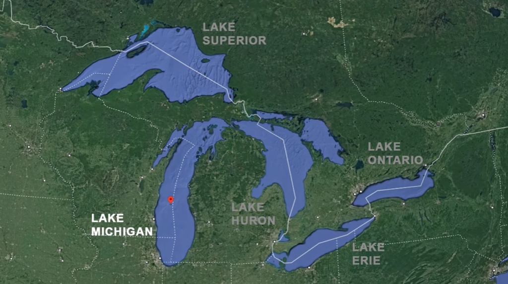
Lake Michigan is one of the five Great Lakes of North America. Stretching across the heart of the Midwest, it has played a vital role in shaping the region’s geography, climate, economy, and history. It is part of the larger Great Lakes system, which also includes Lake Superior, Lake Huron, Lake Erie, and Lake Ontario. The lake is surrounded by numerous sand dunes, and the shoreline features several notable sand dune areas. One particularly famous region for sand dunes along Lake Michigan is the Sleeping Bear Dunes National Lakeshore in the state of Michigan.
With its vast freshwater reserves, long sandy shorelines, major port cities, and rich ecosystems, Lake Michigan functions almost like an inland sea. From supporting commercial shipping and supplying drinking water to influencing weather patterns and sustaining diverse wildlife, Lake Michigan remains one of the most important natural features of the United States. Lake Michigan has historically played a crucial role in transportation, connecting the Midwest to the Atlantic Ocean via the Saint Lawrence Seaway.
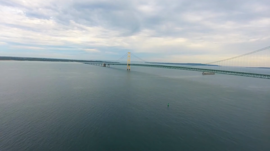
Table of Contents
Location of Lake Michigan: Country, States, Cities
Lake Michigan holds a unique geographical position because it is the only Great Lake located entirely within one country. It lies completely within the United States of America, making it distinct from the other Great Lakes that are shared with Canada.
Geographically, Lake Michigan is situated in the north-central United States, forming part of the Great Lakes–St. Lawrence River system. Although it is hydrologically connected to Lake Huron through the Straits of Mackinac, Lake Michigan is considered a separate lake due to its distinct basin and shoreline.
States Bordering Lake Michigan
Lake Michigan is bordered by four U.S. states, each contributing to its shoreline, ports, and economic importance.
| State | Shoreline Position |
|---|---|
| Michigan | Eastern and northern shores |
| Wisconsin | Western shore |
| Illinois | Southwestern shore |
| Indiana | Southeastern shore |
Major Cities on Lake Michigan
Lake Michigan supports several large cities and port towns that developed along its shores due to access to freshwater, trade routes, and transportation. These cities play an important role in commerce, tourism, and industry in the Great Lakes region.
| City | State | Significance |
|---|---|---|
| Chicago | Illinois | Largest city on Lake Michigan, located on the southwestern shore, major economic hub |
| Milwaukee | Wisconsin | Important port and manufacturing center on the western shore |
| Green Bay | Wisconsin | Located at the northern end of the lake, known for its port. |
| Gary | Indiana | Located in the southern part of the lake, Major steel-producing city |
| Muskegon | Michigan | Historic port city on the eastern shore |
| Grand Haven | Michigan | Known for its beaches and as a summer destination |
| Sheboygan | Wisconsin | Known for freshwater surfing |
| Racine | Wisconsin | Industrial and cultural center |

Size of Lake Michigan: Surface Area, Volume, Length, Width, Shoreline, Depth
Lake Michigan is one of the largest freshwater lakes in the world by surface area and volume. Its size significantly influences climate, shipping, and ecosystems across the surrounding states.
| Feature | Measurement |
|---|---|
| Surface Area | Approximately 22,300 square miles (57,800 sq km) |
| Volume | Approximately 1,180 cubic miles (4,920 cubic km) |
| Maximum Length | 307 miles (494 km) from north to south |
| Maximum Width | 118 miles (190 km) |
| Shoreline Length | Roughly 1,640 miles (2,639 km), including islands |
| Maximum Depth | 923–925 feet (281–282 meters) in the Chippewa Basin |
| Average Depth | 279 feet (85 meters) |
Surface Area of Lake Michigan
Lake Michigan covers approximately 22,300 square miles, making it the third-largest Great Lake by surface area. Its vast open water creates conditions similar to an inland sea.
Volume of Lake Michigan
The lake holds nearly 1,180 cubic miles of freshwater, ranking it second among the Great Lakes by volume. This enormous quantity of water serves as a critical freshwater resource for millions of people.
Maximum Length of Lake Michigan
Lake Michigan stretches roughly 307 miles (494 km) from north to south, giving it a long and narrow shape that influences wind patterns and wave formation.
Maximum Width of Lake Michigan
At its widest point, Lake Michigan measures about 118 miles (190 km) and approximately 91 miles (146 km) wide at its narrowest point.
Shoreline Length of Lake Michigan
Including its islands, Lake Michigan has a shoreline of approximately 1,640 miles (2,639 km), featuring sandy beaches, rocky cliffs, dunes, and wetlands.
Depth of Lake Michigan
The deepest point of Lake Michigan reaches 923–925 feet (281–282 meters) in the Chippewa Basin, while its average depth is 279 feet (85 meters) much shallower. The cold, deep waters help preserve shipwrecks and sustain cold-water fish species.
Formation and History of Lake Michigan
Lake Michigan was formed at the end of the last Ice Age, roughly 10,000 to 12,000 years ago, when massive continental glaciers covered much of North America. As these glaciers advanced, they carved deep basins into the bedrock through erosion. When the climate warmed and the glaciers began to retreat, meltwater filled these basins, giving rise to the Great Lakes, including Lake Michigan. The lake’s long, narrow shape reflects the movement and pressure of glacial ice that flowed primarily from north to south.

In its early stages, Lake Michigan went through several prehistoric phases as water levels rose and fell in response to glacial melting and changing outlets. At times, it existed as part of larger glacial lakes and later became connected to Lake Huron through the Straits of Mackinac, a link that remains today. Although Lake Michigan and Lake Huron are hydrologically one body of water, they are recognized as separate lakes due to their distinct shorelines and basins.
Long before European contact, the shores of Lake Michigan were inhabited by Native American tribes such as the Ojibwe, Potawatomi, Menominee, and Ottawa, who relied on the lake for fishing, transportation, and trade. The lake served as a natural highway, allowing movement between inland waterways and supporting regional commerce.
European exploration began in the 17th century, with French explorers and fur traders using Lake Michigan as part of major trade routes. During the 18th and 19th centuries, the lake became increasingly important for settlement and economic development. Ports and cities grew along its shores as shipping expanded, especially with the transport of timber, grain, iron ore, and coal.
The opening of canals and, later, the Saint Lawrence Seaway strengthened Lake Michigan’s role in international trade by linking the Midwest to the Atlantic Ocean. By the 20th century, the lake had become a backbone of American industrial growth. Today, while commercial shipping continues, Lake Michigan is also valued for recreation, environmental conservation, and its historical legacy as a driver of regional development.
| Time Period | Key Events and Developments |
|---|---|
| Last Ice Age (about 12,000 years ago) | Massive continental glaciers carved deep basins into the land, shaping the area that would become Lake Michigan. |
| Post-Glacial Period | Melting glaciers filled the basin with freshwater, forming Lake Michigan and the other Great Lakes. |
| Early Lake Stages | Water levels rose and fell, and Lake Michigan went through several prehistoric lake phases before stabilizing. |
| Connection to Lake Huron | The Straits of Mackinac formed, permanently linking Lake Michigan with Lake Huron as one hydrological system. |
| Pre-European Era | Native American tribes such as the Ojibwe, Potawatomi, Menominee, and Ottawa used the lake for fishing, trade, and transportation. |
| 17th Century | French explorers and fur traders began navigating Lake Michigan as part of major inland trade routes. |
| 18th–19th Centuries | Ports and settlements expanded along the shoreline, and the lake became crucial for moving timber, grain, iron ore, and coal. |
| 20th Century | Industrial growth increased shipping activity, while cities like Chicago and Milwaukee emerged as major lake ports. |
| Modern Era | Lake Michigan remains vital for transportation, freshwater supply, recreation, and environmental conservation. |
Major Rivers Feeding Lake Michigan
Lake Michigan receives freshwater from nearly 300 rivers and streams spread across a drainage basin of about 45,600 square miles. These waterways play a critical role in maintaining the lake’s water balance, ecosystems, and water quality. Most of the inflow comes from the states of Michigan, Wisconsin, and Indiana, with rivers entering from the eastern, northern, and western shores. Among all tributaries, the Grand River of Michigan stands out as the largest contributor in terms of length, watershed size, and discharge.
Major Eastern Tributaries of Lake Michigan (Michigan)
Rivers flowing from Michigan’s Lower Peninsula form some of the most important inflows into Lake Michigan. These rivers drain large watersheds and deliver substantial volumes of water directly into the lake’s eastern shoreline.
| River | Length | Key Significance |
|---|---|---|
| Grand River | 252 miles | Longest river in Michigan; largest watershed draining into Lake Michigan |
| St. Joseph River | 206 miles | Major southern inflow originating in southern Michigan |
| Muskegon River | 216 miles | Important eastern tributary with strong discharge |
| Kalamazoo River | 130 miles | Drains agricultural and industrial regions |
| Manistee River | 190 miles | Significant northern Lower Peninsula inflow |
Major Northern and Western Tributaries (Wisconsin and Michigan Upper Peninsula)
Several major rivers enter Lake Michigan through Green Bay or along the northwestern shoreline. These rivers drain large forested and agricultural regions and are vital to the lake’s northern ecosystem.
| River System | Length | Location |
|---|---|---|
| Fox–Wolf River System | — | Drains into Green Bay, Wisconsin |
| Menominee River | 116 miles | Forms the border between Wisconsin and Michigan’s Upper Peninsula |
| Milwaukee River | 104 miles | Major inflow serving the Milwaukee metro area |
| Escanaba River | 120 miles | Enters the northern end of Lake Michigan |
Other Notable Inflows and Hydrologic Connections
In addition to traditional rivers, Lake Michigan is connected to other waterways that influence its water levels and flow dynamics.
| Waterway | Type | Importance |
|---|---|---|
| Straits of Mackinac | Natural strait | Connects Lake Michigan and Lake Huron, balancing water levels |
| Manistique River | River | Important Upper Peninsula tributary |
| Pere Marquette River | River | Known for high water quality and recreation |
| Chicago River | Modified river | Flow reversed in 1900 to drain away from Lake Michigan |
Islands in Lake Michigan
Lake Michigan contains numerous islands, most of which are concentrated in the northern part of the lake. These islands vary widely in size, landscape, and use. Some, such as Beaver Island, support permanent communities, while others remain largely undeveloped and are protected for wildlife conservation. Several islands are part of national lakeshores and state parks, making them popular destinations for hiking, camping, and exploring historic shipwreck sites.
The largest and most prominent island group includes Beaver Island, along with the Manitou Islands and the Fox Islands. In addition, Green Bay—an arm of Lake Michigan—contains a number of well-known islands shared between Michigan and Wisconsin.
| Island Name | State | County / Region | Island Group | Key Features |
|---|---|---|---|---|
| Beaver Island | Michigan | Charlevoix County | Beaver Island Archipelago | Largest island; permanent population; ferry and air access |
| Garden Island | Michigan | Charlevoix County | Beaver Island Archipelago | Largely undeveloped; historic settlement remains |
| High Island | Michigan | Charlevoix County | Beaver Island Archipelago | Forested terrain; limited access |
| Hog Island | Michigan | Charlevoix County | Beaver Island Archipelago | Small island; wildlife habitat |
| Gull Island | Michigan | Charlevoix County | Beaver Island Archipelago | Protected bird nesting area |
| Hat Island | Michigan | Charlevoix County | Beaver Island Archipelago | Wildlife refuge; restricted access |
| Pismire Island | Michigan | Charlevoix County | Beaver Island Archipelago | Part of national wildlife refuge |
| Shoe Island | Michigan | Charlevoix County | Beaver Island Archipelago | Managed for habitat protection |
| North Manitou Island | Michigan | Leelanau County | Manitou Islands | Backpacking, remote camping, beaches |
| South Manitou Island | Michigan | Leelanau County | Manitou Islands | Lighthouse, shipwrecks, hiking |
| North Fox Island | Michigan | Leelanau County | Fox Islands | Historic lighthouse; remote |
| South Fox Island | Michigan | Leelanau County | Fox Islands | Lighthouse and shipwreck history |
| Washington Island | Wisconsin | Door County | Green Bay Islands | Largest Green Bay island; residential |
| Rock Island | Wisconsin | Door County | Green Bay Islands | State park; preserved natural landscape |
| Summer Island | Michigan | Delta County | Green Bay Islands | Sparse development; natural habitat |
| Poverty Island | Michigan | Delta County | Green Bay Islands | Shipwreck sites nearby |
| St. Martin Island | Michigan | Delta County | Green Bay Islands | Historic lighthouse location |
| Chambers Island | Wisconsin | Door County | Other Islands | Hiking trails; seasonal residents |
| St. Helena Island | Michigan | Mackinac County | Other Islands | Former lighthouse site |
| Grand Island | Michigan | Alger County | Upper Peninsula Islands | Recreation and cliffs; often associated with Lake Michigan |
Temperature of Lake Michigan
Lake Michigan’s water temperature changes throughout the year. During winter, surface temperatures drop to near-freezing levels, often allowing ice to form along the shoreline. In contrast, late summer brings the warmest conditions, making the lake more suitable for swimming and water recreation. Because of its depth and size, Lake Michigan warms and cools slowly, causing noticeable seasonal delays compared to air temperatures.
Monthly Average Surface Water Temperature of Lake Michigan
The table below shows typical monthly average surface water temperatures based on long-term observations.
| Month | Average Water Temperature (°F (°C)) | Seasonal Conditions |
|---|---|---|
| January | 37.9°F (3.3°C) | Ice begins forming along shallow shorelines |
| February | 36.9°F (2.7°C) | Coldest water temperatures of the year |
| March | 36.0°F (2.2°C) | Water remains near winter minimum |
| April | 38.8°F (3.8°C) | Gradual warming starts as ice melts |
| May | 46.0°F (7.8°C) | Cold water dominates despite warmer air |
| June | 58.0°F (14.4°C) | Faster warming, still cool for swimming |
| July | 66.0°F (18.9°C) | Comfortable conditions for most swimmers |
| August | 70.5°F (21.4°C) | Warmest month and peak beach season |
| September | 65.0°F (18.3°C) | Retains summer warmth early in the month |
| October | 57.0°F (13.9°C) | Rapid cooling with fall weather |
| November | 48.0°F (8.9°C) | Transition back toward winter temperatures |
| December | 41.0°F (5.0°C) | Cooling continues toward freezing point |
Wildlife in Lake Michigan
Lake Michigan supports a rich and diverse range of wildlife, shaped by its vast freshwater system, surrounding wetlands, sandy dunes, rocky shorelines, and tributary rivers. The lake and its coastal habitats provide food, breeding grounds, and migration corridors for many species. While human activity has influenced the ecosystem, Lake Michigan continues to sustain a wide variety of animals and plants adapted to freshwater environments.
Mammals Found Around Lake Michigan
The shores and nearshore wetlands of Lake Michigan are home to several semi-aquatic and land-based mammals. These animals depend on the lake for food, shelter, and seasonal movement.
| Mammal | Habitat and Role |
|---|---|
| River otter | Lives along shorelines and rivers; feeds on fish |
| Beaver | Builds dams in tributaries and wetlands |
| Muskrat | Common in marshes and shallow coastal areas |
| Mink | Found near rocky and vegetated shorelines |
| White-tailed deer | Uses coastal forests and dunes |
Birds of Lake Michigan
Lake Michigan lies along major migratory flyways and attracts a wide variety of bird species throughout the year. Its islands and coastal wetlands are especially important nesting and resting sites.
| Bird Type | Examples |
|---|---|
| Waterfowl | Mallards, Canada geese, scaup |
| Shorebirds | Sandpipers, plovers |
| Gulls and terns | Herring gull, Caspian tern |
| Raptors | Bald eagle, osprey |
| Songbirds | Warblers, sparrows (seasonal migrants) |
Fish Species in Lake Michigan
Lake Michigan supports both native and introduced fish species, making it an important recreational and commercial fishery.
| Fish Species | Status |
|---|---|
| Lake trout | Native |
| Lake sturgeon | Native |
| Yellow perch | Native |
| Lake whitefish | Native |
| Smallmouth bass | Native |
| Chinook salmon | Introduced |
| Coho salmon | Introduced |
Biggest Fish in Lake Michigan
The lake sturgeon is the largest fish species found in Lake Michigan. This ancient fish can grow over 7 feet long and weigh more than 200 pounds, making it one of the most remarkable residents of the lake.
Reptiles and Amphibians Near Lake Michigan
Although fewer in number, reptiles and amphibians are found in wetlands and coastal zones surrounding the lake.
| Species Type | Examples |
|---|---|
| Turtles | Painted turtle, snapping turtle |
| Frogs | Northern leopard frog, green frog |
| Salamanders | Mudpuppy |
Aquatic Plants and Algae
Aquatic vegetation plays a key role in Lake Michigan’s ecosystem by providing habitat and stabilizing sediments.
| Plant Type | Common Examples |
|---|---|
| Submerged plants | Pondweed, eelgrass |
| Algae | Cladophora |
| Coastal vegetation | Cattails, bulrushes |
Famous Ships Sunk in Lake Michigan
Lake Michigan has claimed many well-known vessels over the centuries, earning a reputation as one of the most dangerous lakes for historic navigation. Among the most famous shipwrecks are the SS Carl D. Bradley, the passenger steamer Lady Elgin, and the legendary Rouse Simmons, often remembered as the “Christmas Tree Ship.” Other historically important losses include the SS Wisconsin, SS Anna C. Minch, and Le Griffon, the earliest European-style sailing vessel known to have entered the upper Great Lakes.
Most of these ships were lost due to violent storms, fires, heavy fog, structural failures, or collisions, often occurring in the deep and unpredictable waters of the lake. Several wrecks are associated with the so-called Lake Michigan Triangle, an area linked to unusual weather patterns and unexplained disappearances.
Major Shipwrecks in Lake Michigan
| Ship Name | Year Sunk | Vessel Type | Location / Cause | Historical Importance |
|---|---|---|---|---|
| SS Carl D. Bradley | 1958 | Freighter | Broke apart in storm near Gull Island | Known as the “Queen of the Lakes”; 33 crew members lost |
| Lady Elgin | 1860 | Passenger steamer | Collision off Highland Park, Illinois | Deadliest passenger shipwreck on Lake Michigan |
| Rouse Simmons | 1912 | Schooner | Sank in winter storm en route to Chicago | Famous “Christmas Tree Ship” |
| Le Griffon | 1679 | Sailing vessel | Disappeared near Green Bay | First European-style ship on the upper Great Lakes |
| SS Anna C. Minch | 1940 | Cargo ship | Broke in two during Armistice Day Blizzard | Entire crew lost |
| SS Wisconsin | 1929 | Passenger steamer | Sank in storm near Kenosha, Wisconsin | Early 20th-century passenger vessel |
| SS Appomattox | 1905 | Wooden freighter | Ran aground near Milwaukee in dense fog | One of the largest wooden ships on the lakes |
| Steamer L.R. Doty | 1898 | Wooden freighter | Lost in severe storm | No survivors; major maritime tragedy |
Scary Facts About Lake Michigan
Lake Michigan is often seen as peaceful, with long beaches and calm blue waters, but it can quickly become one of the most dangerous lakes in North America. Its massive size allows it to behave like an inland sea, generating powerful storms, towering waves, and strong currents with little warning. Cold water temperatures persist for much of the year, increasing the risk of sudden cold shock, even during warm summer weather.
Over the centuries, Lake Michigan has earned a fearsome reputation among sailors and coastal communities. Thousands of shipwrecks lie hidden beneath its surface, many of them remarkably preserved in cold freshwater. Certain areas of the lake, particularly the region known as the Lake Michigan Triangle, are associated with mysterious disappearances and unexplained navigation problems. These natural and historical dangers make Lake Michigan both fascinating and formidable.
Scary Facts and Dangers of Lake Michigan
| Category | Scary Fact | Why It’s Dangerous |
|---|---|---|
| Weather | Sudden storms can form within minutes | Produces violent winds and massive waves |
| Waves | Storm waves can exceed 20 feet | Can overwhelm boats and coastal structures |
| Water Temperature | Cold water dominates most of the year | Causes cold shock and hypothermia |
| Currents | Powerful rip and structural currents | Pull swimmers away from shore |
| Shipwrecks | Thousands of wrecks on the lakebed | Hazard to navigation and diving |
| Depth | Maximum depth over 900 feet | Extremely cold, dark, and dangerous |
| Visibility | Dense fog occurs frequently | Leads to collisions and disorientation |
| Lake Michigan Triangle | Area linked to disappearances | Navigation and weather anomalies reported |
| Preservation | Freshwater preserves wrecks | Hidden underwater obstacles remain intact |
| Proximity to Shore | Deep drop-offs near beaches | Swimmers can lose footing suddenly |
Importance of Lake Michigan
Lake Michigan plays a vital role in the natural, economic, and cultural life of the United States. As the only Great Lake located entirely within the U.S., it serves as a major source of freshwater for millions of people across several states. The lake influences regional climate, supports diverse ecosystems, and sustains important industries such as shipping, fishing, and tourism. Its vast shoreline and clean freshwater also make it a cornerstone of recreation, urban development, and environmental conservation in the Midwest.
Beyond its practical value, Lake Michigan has shaped history and settlement patterns for centuries. Indigenous communities relied on its waters long before European exploration, and later it became a key transportation route during America’s industrial growth. Today, Lake Michigan continues to support modern cities, protect wildlife habitats, and provide drinking water, making it one of the most important freshwater lakes in North America.
Importance of Lake Michigan – Key Aspects
| Aspect | Importance | Details |
|---|---|---|
| Freshwater Supply | Drinking water source | Supplies water to millions in Illinois, Michigan, Wisconsin, and Indiana |
| Economic Value | Supports regional economy | Enables shipping, fishing, and manufacturing |
| Transportation | Major inland shipping route | Connects ports to the Great Lakes–St. Lawrence Seaway |
| Climate Influence | Moderates regional weather | Reduces temperature extremes and adds lake-effect snow |
| Biodiversity | Supports ecosystems | Home to fish, birds, and coastal wetlands |
| Recreation | Tourism and leisure | Boating, beaches, fishing, and water sports |
| Cultural History | Historical significance | Important to Native American and early settler communities |
| Urban Development | Growth of major cities | Helped develop Chicago, Milwaukee, and other ports |
| Environmental Role | Water filtration & habitats | Wetlands improve water quality and protect shorelines |
| Scientific Research | Climate and ecology studies | Used for freshwater and environmental research |
Quick Facts About Lake Michigan
| Fact | Details |
|---|---|
| Type | Freshwater lake |
| Lake System | Great Lakes |
| Unique Feature | Only Great Lake located entirely within the United States |
| Location | Northern United States |
| States Bordering | Illinois, Indiana, Michigan, Wisconsin |
| Surface Area | ~22,400 sq miles (58,000 sq km) |
| Length | ~307 miles (494 km) |
| Maximum Width | ~118 miles (190 km) |
| Average Depth | ~279 ft (85 m) |
| Maximum Depth | ~923 ft (281 m) |
| Water Volume | ~1,180 cubic miles (4,918 cubic km) |
| Shoreline Length | ~1,640 miles (2,640 km), including islands |
| Elevation Above Sea Level | ~577 ft (176 m) |
| Inflows | Over 100 rivers and streams |
| Outflow | Straits of Mackinac to Lake Huron |
| Connection to Ocean | Via Great Lakes–St. Lawrence Seaway |
| Major Cities on Shore | Chicago, Milwaukee, Green Bay, Gary, Muskegon |
| Largest Island | Beaver Island |
| Number of Islands | Dozens of islands and archipelagos |
| Average Summer Water Temperature | ~65–70°F (18–21°C) |
| Average Winter Water Temperature | ~36–39°F (2–4°C) |
| Ice Coverage | Partial freezing during winter |
| Fish Species | Lake trout, salmon, whitefish, perch |
| Wildlife | Migratory birds, seabirds, aquatic mammals |
| Economic Importance | Shipping, fishing, tourism |
| Recreational Activities | Swimming, boating, kayaking, fishing |
| Famous Shipwrecks | Lady Elgin, SS Carl D. Bradley, Rouse Simmons |
| Environmental Role | Drinking water supply and ecosystem support |
| Protected Areas | National lakeshores and wildlife refuges |
Frequently Asked Questions About Lake Michigan
Q. Where is Lake Michigan?/Which states border Lake Michigan?/Is Lake Michigan in the US?
A. Lake Michigan is located in the northern United States and is bordered by four U.S. states: Michigan, Indiana, Illinois, and Wisconsin.
Q. How big is Lake Michigan?/ How large is Lake Michigan?
A. Lake Michigan is the second-largest Great Lake by volume (1,180 cubic miles) and the third-largest by surface area. (22,400 square miles)
Q. How wide is Lake Michigan at its narrowest point?
A. Lake Michigan is approximately 91 miles (146 kilometers) wide at its narrowest point.
Q. How deep is Lake Michigan?/How deep is Lake Michigan in feet?
A. Lake Michigan has an average depth of around 279 feet (85 meters).
Q. What is the deepest part of Lake Michigan?
A. The maximum depth is approximately 923 feet (281 meters), located off the eastern coast near the Wisconsin-Michigan border in the “Chippewa Basin” or “Chippewa Trough.”
Q. How wide is Lake Michigan?
A. Lake Michigan is approximately 118 miles (190 kilometers) wide at its widest point, from east to west, near Michigan City, Indiana to the westernmost point.
Q. How many acres is Lake Michigan?
A. Lake Michigan has a surface area of about 14.3 million acres (22,400 square miles).
Q. How many gallons of water are in Lake Michigan?
A. Lake Michigan contains roughly 1.3 trillion gallons of water.
Q. Which great lake measures 307 miles in length?
A. Lake Michigan is the Great Lake that measures approximately 307 miles (494 km) in length.
Q. Why is Lake Michigan important?
A. Lake Michigan is important for freshwater supply, transportation, recreation, fishing, and supporting regional economies.