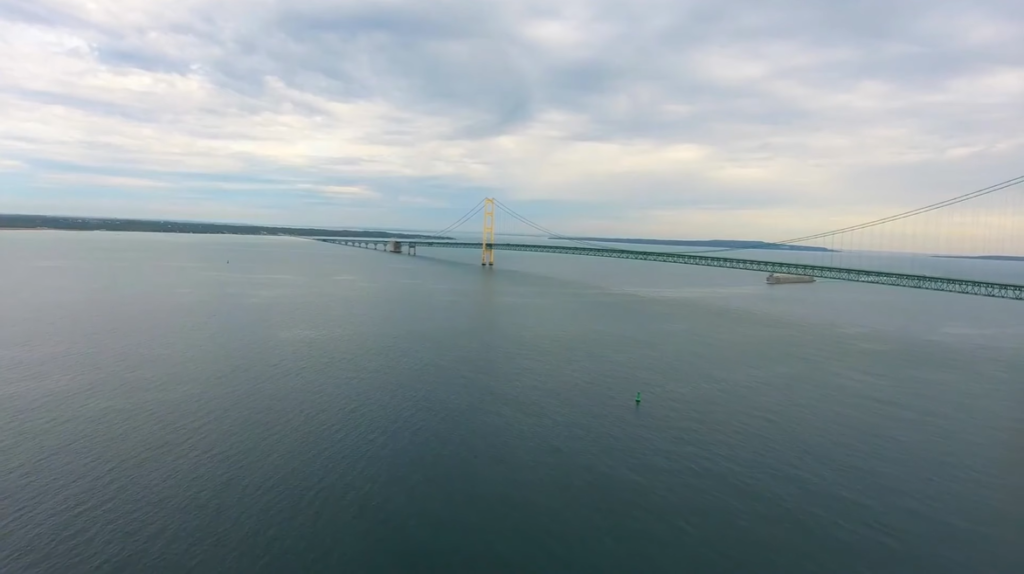
Lake Powell is a vast reservoir located on the Colorado River, primarily in southern Utah and northern Arizona. It stands as the second-largest artificial reservoir in the United States, surpassed only by Lake Mead. The lake was named after John Wesley Powell, the explorer who led the first expedition down the Colorado River through the Grand Canyon in 1869. This historic connection to Powell highlights the region’s significance in the exploration of the American West.
Over time, Lake Powell has become a popular destination for outdoor enthusiasts. It offers a wide range of recreational activities, from boating and fishing to swimming, hiking, and camping. The lake’s many side canyons and hidden coves provide opportunities for exploration, making it a paradise for adventurers. Visitors can enjoy the natural beauty of the surrounding Glen Canyon National Recreation Area, which includes a mix of desert landscapes, rock formations, and scenic vistas.
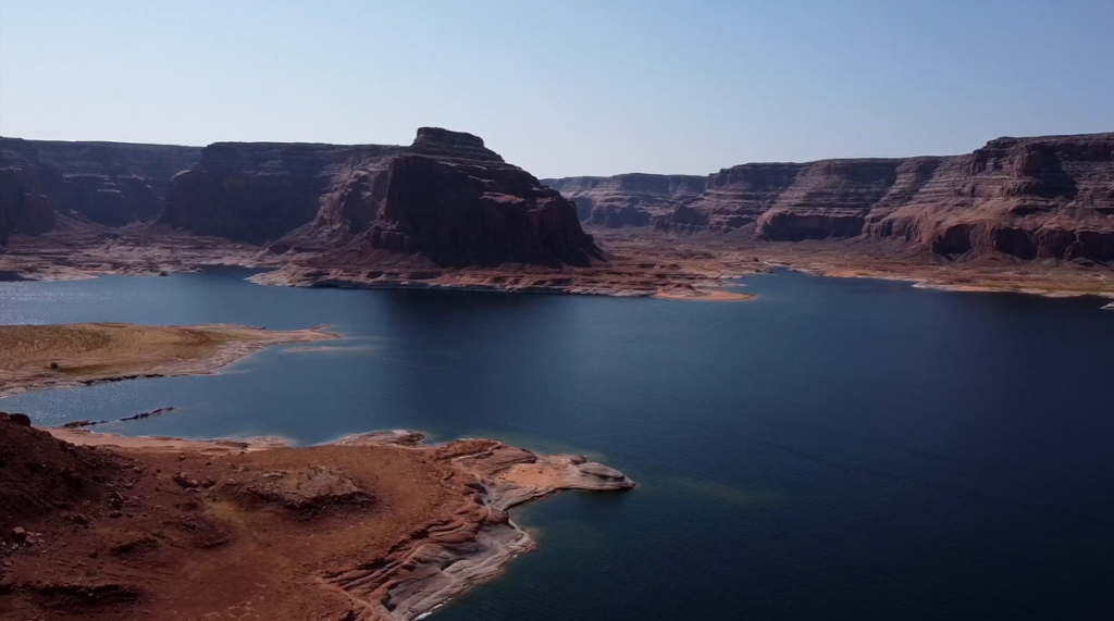
Table of Contents
Location of Lake Powell: Country, States, Cities
Lake Powell is the second-largest man-made reservoir located in the United States, primarily spanning southern Utah (Garfield, Kane, and San Juan counties) and northern Arizona (Coconino County). It forms a major part of the Glen Canyon National Recreation Area and sits on the Colorado Plateau, offering desert scenery along its vast waters.
The main city serving as a hub for tourism and visitor services is Page, Arizona, which provides access to marinas, lodging, and recreational facilities. Key marinas around the lake include Wahweap and Antelope Point near Page, Arizona, as well as Bullfrog and Halls Crossing in Utah, facilitating boating and houseboat rentals across the lake.
| Parameter | Details |
|---|---|
| Country | United States |
| States | Utah (majority of the lake) and Arizona |
| Counties | Garfield, Kane, San Juan (Utah); Coconino (Arizona) |
| Region | Colorado Plateau |
| Primary City / Tourism Hub | Page, Arizona |
| Major Marinas | Wahweap Marina (AZ), Antelope Point Marina (AZ), Bullfrog Marina (UT), Halls Crossing Marina (UT) |
| River | Colorado River |
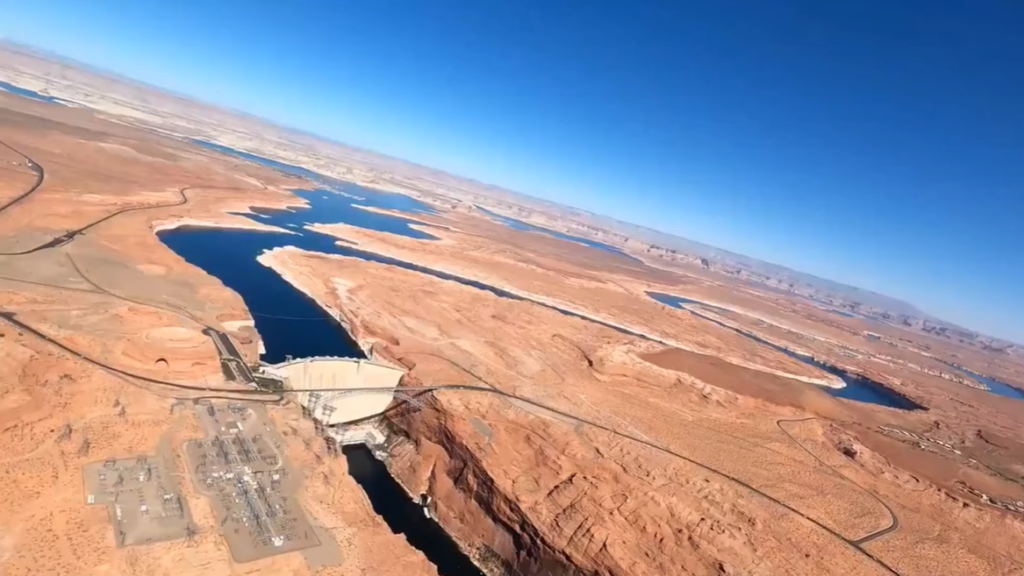
| Dam Location | Glen Canyon Dam, Arizona |
Size of Lake Powell: Surface Area, Volume, Length, Width, Depth Shoreline
| Parameter | Measurement |
|---|---|
| Surface Area | 161,390 acres (approx. 252 sq mi / 653 sq km) |
| Water Volume (Capacity) | Approximately 26–27 million acre-feet |
| Length | About 186 miles (299 km) |
| Maximum Width | Approximately 25 miles (40 km) |
| Maximum Depth | 560–583 feet (170–178 m) |
| Shoreline Length | Over 1,960 to 2,000+ miles |
Surface Area of Lake Powell
Lake Powell has a surface area of approximately 161,390 acres, which is equivalent to about 252 square miles (653 square kilometers) when the reservoir is at full pool. The lake’s surface area fluctuates significantly depending on water levels, expanding during wet years and shrinking during drought periods.
Volume of Lake Powell
At maximum capacity, Lake Powell can store around 26 to 27 million acre-feet of water. This immense volume makes it the second-largest artificial reservoir in the United States by storage capacity, playing a vital role in water management and hydroelectric power generation across the Colorado River Basin.
Length of Lake Powell
Lake Powell stretches for roughly 186 miles (299 kilometers) from the Glen Canyon Dam in northern Arizona into southern Utah. Its long, winding shape follows the flooded canyons of the Colorado River and its tributaries, making it one of the longest reservoirs in North America.
Width of Lake Powell
While much of Lake Powell is narrow and canyon-bound, the lake reaches a maximum width of about 25 miles (40 kilometers) in wider sections such as Padre Bay. These broad areas contrast sharply with the tight sandstone corridors found elsewhere along the reservoir.
Depth of Lake Powell
The maximum depth of Lake Powell ranges between 560 and 583 feet (170–178 meters) near the Glen Canyon Dam. Depth varies widely across the lake, with deep submerged channels near the dam and much shallower waters in upper canyon arms and side inlets.
Shoreline Length of Lake Powell
Lake Powell has an exceptionally long shoreline, measuring over 1,960 miles when full. This extensive shoreline is created by hundreds of flooded side canyons and coves, giving the reservoir more shoreline than the entire U.S. West Coast and contributing to its popularity for boating and camping.
Formation and History of Lake Powell
Lake Powell is a vast man-made reservoir formed by the damming of the Colorado River, but its history stretches back millions of years, long before human engineering reshaped the landscape. The lake occupies what was once Glen Canyon, a dramatic sandstone canyon carved by the Colorado River through the Colorado Plateau.
| Period / Year | Event |
|---|---|
| Over 200 million years ago | Sandstone, shale, and limestone layers formed across the Colorado Plateau through ancient deserts, rivers, and shallow seas. |
| Millions of years ago | Uplift of the Colorado Plateau increased the erosive power of the Colorado River, carving Glen Canyon and its side canyons. |
| 200 BCE – 1300 CE | Ancestral Puebloans inhabited the Glen Canyon region, leaving behind cliff dwellings, granaries, petroglyphs, and artifacts. |
| Pre-1800s | Navajo (Diné) and Ute peoples lived, traveled, and traded throughout the Glen Canyon area. |
| 1869 | Major John Wesley Powell led the first documented expedition through the Colorado River and Grand Canyon region. |
| Late 1800s | Mormon settlers explored Glen Canyon; Lee’s Ferry became a key river crossing and settlement site. |
| 1922 | Colorado River Compact signed, dividing water rights between Upper and Lower Basin states. |
| 1956 | U.S. Congress authorized the Colorado River Storage Project (CRSP), approving construction of Glen Canyon Dam. |
| 1956 | Construction of Glen Canyon Dam began near the Arizona–Utah border. |
| 1963 | Glen Canyon Dam completed; Colorado River flow blocked and reservoir filling began. |
| 1963–1980 | Lake Powell gradually filled, submerging Glen Canyon and forming the reservoir’s complex shoreline. |
| 1980 | Lake Powell reached full pool capacity for the first time. |
| Late 20th century | Lake Powell became a major center for recreation, tourism, and hydroelectric power generation. |
| 21st century | Prolonged drought and climate change caused significant water-level declines, exposing submerged canyon features. |
| Present day | Lake Powell remains a critical water storage reservoir and a focal point of environmental and water management debates. |
Geological Formation of Glen Canyon
The foundation of Lake Powell lies in the geology of the region. Over 200 million years ago, layers of sandstone, shale, and limestone were deposited in ancient deserts, riverbeds, and shallow seas. The most prominent rock layer, Navajo Sandstone, was formed from wind-blown sand dunes that later hardened into stone. Over millions of years, tectonic uplift raised the Colorado Plateau, increasing the river’s erosive power. The Colorado River gradually cut deep into these rock layers, sculpting Glen Canyon with steep cliffs, narrow side canyons, and winding passages.
Human History Before the Dam
Before Lake Powell existed, Glen Canyon was home to Indigenous peoples for thousands of years. Ancestral Puebloans (Anasazi) lived in the region between approximately 200 BCE and 1300 CE, leaving behind cliff dwellings, granaries, petroglyphs, and pottery fragments. Later, Navajo (Diné) and Ute peoples inhabited and traveled through the canyon, relying on the river and surrounding land for sustenance, trade, and spiritual practices.
In the late 1800s and early 1900s, Mormon settlers explored parts of Glen Canyon, establishing small river crossings and settlements. One of the most notable was Lee’s Ferry, which became an important crossing point on the Colorado River and later a boundary marker for water rights in the American Southwest.
The Colorado River Storage Project
By the early 20th century, the growing population of the southwestern United States increased demand for reliable water supplies, flood control, and hydroelectric power. In response, the federal government developed the Colorado River Storage Project (CRSP), authorized by Congress in 1956. The project aimed to regulate river flow, store water during wet years, and ensure water delivery to Upper Basin states, including Utah, Colorado, Wyoming, and New Mexico.
Glen Canyon Dam was selected as the key structure for water storage, despite opposition from conservationists who sought to protect Glen Canyon’s natural beauty. The decision marked a turning point in the region’s environmental and political history.
Construction of Glen Canyon Dam
Construction of Glen Canyon Dam began in 1956 near the Arizona-Utah border and was completed in 1963. Standing 710 feet (216 meters) tall, the dam is one of the largest concrete arch dams in the United States. Its construction involved diverting the Colorado River through massive tunnels and pouring millions of cubic yards of concrete.
The dam was designed to generate hydroelectric power, control floods, and create a long-term water reservoir for the Southwest. Once the dam was completed, gates were closed and water began backing up into Glen Canyon.
Formation of Lake Powell
The filling of Lake Powell began in 1963 and took 17 years, reaching full capacity in 1980. As the reservoir filled, hundreds of miles of canyons, rock formations, archaeological sites, and historic river corridors were submerged beneath the rising water. The newly formed lake was named Lake Powell in honor of Major John Wesley Powell, the 19th-century explorer who led the first documented expedition through the Grand Canyon and the Colorado River in 1869.
As water flooded the canyon system, it created an intricate shoreline with countless side arms, coves, and bays, transforming Glen Canyon into a massive recreational reservoir.
Temperature of Lake Powell
Lake Powell experiences wide temperature variations throughout the year due to its location in the arid desert climate of the American Southwest. Both water temperature and air temperature change significantly by season, influencing recreational activities, aquatic life, and visitor safety.
Summer Temperature
During summer, Lake Powell warms considerably under intense desert heat. Surface water temperatures typically range between 75°F and 85°F (24°C to 29°C), making the lake ideal for swimming, boating, and water sports. In shallow coves and bays, water temperatures can occasionally rise above 85°F during prolonged heatwaves. Air temperatures in summer often exceed 100°F (38°C), requiring visitors to take precautions against dehydration and heat exposure.
Spring and Fall Temperature
Spring and fall are transitional seasons with moderate temperatures. In spring, water temperatures gradually rise from 55°F to 70°F (13°C to 21°C) as snowmelt increases inflow from the Colorado River. Fall sees a gradual cooling trend, with water temperatures typically ranging from 65°F to 75°F (18°C to 24°C). These seasons are considered ideal for boating, fishing, and sightseeing due to comfortable air temperatures and calmer weather conditions.
Winter Temperature
Winter brings the coolest conditions to Lake Powell. Water temperatures usually drop to around 50°F to 60°F (10°C to 16°C), while air temperatures can fall below freezing, especially at night. Although the lake rarely freezes due to its depth and movement, colder conditions limit swimming and some water activities. Winter is quieter and appeals more to anglers and photographers seeking uncrowded views.
Seasonal Temperature Pattern of Lake Powell
| Season | Average Water Temperature | Typical Air Temperature |
|---|---|---|
| Spring (Mar–May) | 55°F – 70°F (13°C – 21°C) | 60°F – 85°F (16°C – 29°C) |
| Summer (Jun–Aug) | 75°F – 85°F (24°C – 29°C) | 90°F – 105°F+ (32°C – 40°C+) |
| Fall (Sep–Nov) | 65°F – 75°F (18°C – 24°C) | 65°F – 85°F (18°C – 29°C) |
| Winter (Dec–Feb) | 50°F – 60°F (10°C – 16°C) | 35°F – 55°F (2°C – 13°C) |
Month-Wise Surface Temperature of Lake Powell
| Month | Average Surface Water Temperature |
|---|---|
| January | 50–52°F (10–11°C) |
| February | 50–53°F (10–12°C) |
| March | 52–58°F (11–14°C) |
| April | 58–65°F (14–18°C) |
| May | 65–72°F (18–22°C) |
| June | 72–78°F (22–26°C) |
| July | 78–85°F (26–29°C) |
| August | 80–86°F (27–30°C) |
| September | 75–82°F (24–28°C) |
| October | 68–75°F (20–24°C) |
| November | 58–65°F (14–18°C) |
| December | 50–55°F (10–13°C) |
Major Rivers Feeding Lake Powell
Lake Powell is primarily fed by a network of major rivers that drain the Upper Colorado River Basin, making the reservoir one of the most important water storage systems in the western United States. These rivers deliver water, sediment, and nutrients into the lake, sustaining its volume, ecosystem, and role in regional water management. The reservoir itself was formed by the construction of the Glen Canyon Dam, which regulates the flow of these rivers downstream.
Colorado River
The Colorado River is the main and dominant source of water for Lake Powell. Flowing from the Rocky Mountains through the Upper Basin, it enters the reservoir from the east and north, supplying the majority of the lake’s inflow. The Colorado River not only determines the overall water level of Lake Powell but also plays a central role in hydroelectric power generation, flood control, and long-term water storage for the southwestern United States.
San Juan River
The San Juan River is one of the most significant tributaries feeding Lake Powell, joining the reservoir from the east. It contributes a substantial amount of water as well as sediment, which historically shaped the lake’s underwater deltas and shoreline formations. Originating in the San Juan Mountains of Colorado, this river is a critical component of the Upper Basin’s hydrology and strongly influences water quality and sediment dynamics within Lake Powell.
Green River
The Green River is another major contributor to Lake Powell. As one of the largest tributaries of the Colorado River, it converges with the Colorado River upstream before flowing into the upper reaches of the reservoir. The Green River drains vast areas of Wyoming, Utah, and Colorado, making it a key source of inflow during spring snowmelt and wet years. Its contribution is essential for maintaining reservoir levels during seasonal fluctuations.
Escalante River
The Escalante River enters Lake Powell from the northwest and is considered one of the most important desert rivers feeding the reservoir. Although smaller than the Colorado, San Juan, or Green rivers, it plays a significant role during periods of rainfall and snowmelt. The Escalante River also feeds the scenic Escalante Arm of Lake Powell, known for its dramatic canyons and sediment-rich inflows.
Dirty Devil River
The Dirty Devil River flows into Lake Powell from the north and contributes additional water and sediment to the reservoir. While its flow is more variable and often influenced by seasonal storms, it remains an important tributary within the Upper Colorado River Basin. The river’s sediment load has historically contributed to delta formation in the northern reaches of the lake.
| River | Direction of Entry | Importance to Lake Powell |
|---|---|---|
| Colorado River | From the east and north | Primary and dominant source of water; controls overall reservoir level and inflow |
| San Juan River | From the east | Major tributary contributing significant water and sediment |
| Green River | Joins Colorado River upstream | One of the largest tributaries; critical during snowmelt and wet years |
| Escalante River | From the northwest | Important desert river feeding the Escalante Arm of the lake |
| Dirty Devil River | From the north | Seasonal tributary contributing water and sediment |
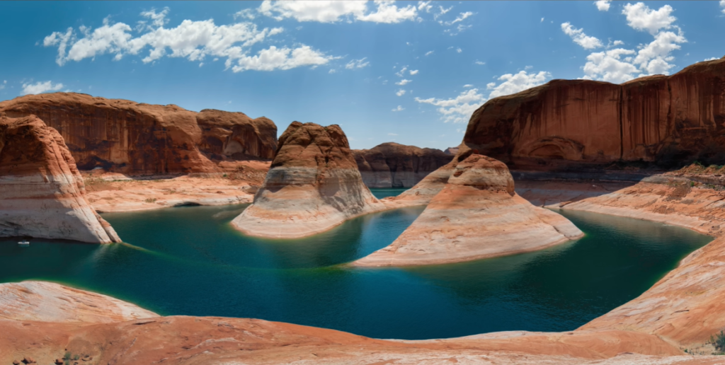
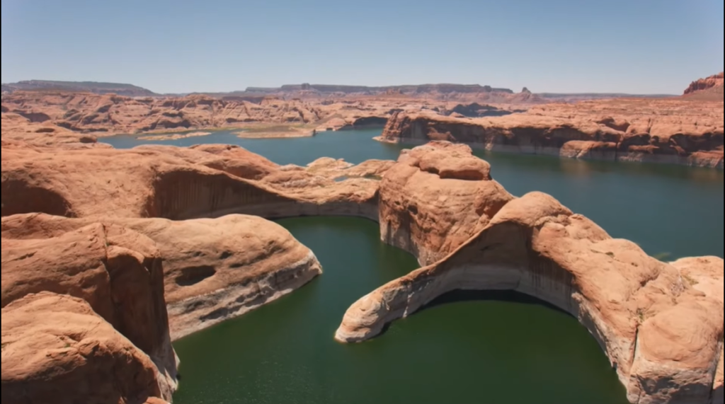
Islands in Lake Powell
Lake Powell is known not only for its vast size but also for its numerous islands, buttes, and rock formations. Unlike natural ocean islands, most of Lake Powell’s islands are actually sandstone mesas, buttes, and canyon walls that become isolated by water when lake levels rise and reconnect to the shoreline when levels fall. This constant transformation makes the lake’s geography dynamic and visually striking.
Formation of Islands and Landmasses
The islands of Lake Powell were created when the filling of the reservoir flooded the intricate canyon system of Glen Canyon. As water levels rose, higher-elevation rock formations remained above the surface, forming islands, while lower ridges became peninsulas or submerged entirely. Because Lake Powell’s water levels fluctuate seasonally and during drought cycles, many islands shift between being fully surrounded by water and partially connected to land.
Antelope Island
Antelope Island is one of the most recognizable islands in Lake Powell and is located in the southern part of the lake, just north of Page, Arizona. Its proximity to major marinas makes it a popular stop for boaters and kayakers. Depending on water levels, Antelope Island may appear as a true island or as a peninsula extending from the shoreline.
Gunsight Butte
Gunsight Butte is a prominent and easily identifiable rock formation rising sharply from the water. Known for its distinctive shape, it often appears completely surrounded by water, especially during higher lake levels. This landmark serves as a navigational reference point and a favorite subject for photographers exploring the lake by boat.
Gregory Butte
Gregory Butte is another significant land feature within Lake Powell. Like many formations in the reservoir, it transitions between an island and a peninsula depending on changing water conditions. Its rugged cliffs and surrounding waters make it a scenic destination for boating and sightseeing.
Castle Rock
Castle Rock is a well-known formation near the Wahweap area, one of the busiest sections of Lake Powell. Easily accessible from nearby marinas, Castle Rock is frequently visited by boaters and kayakers. Its castle-like appearance rising from the water makes it a standout landmark in the southern portion of the lake.
The Rincon
The Rincon is a distinct geological feature within Lake Powell, characterized by dramatic rock formations and narrow waterways. It is often explored by boat or kayak and is valued for its scenic beauty and quieter atmosphere compared to busier marina areas.
Lone Rock
Lone Rock is one of Lake Powell’s most famous landmarks and is located near Wahweap Marina. Often appearing as a large rock island set in a wide sandy bay, Lone Rock is unique because of its nearby beach, which allows for shore access and camping. It remains a popular spot for photography, picnicking, and beach activities, especially during warmer months.
| Island / Formation | Location | Key Characteristics |
|---|---|---|
| Antelope Island | Near Page, Arizona (southern Lake Powell) | Becomes an island or peninsula depending on water level; popular with boaters and kayakers |
| Gunsight Butte | Central Lake Powell | Distinctive landmark often surrounded by water; popular for photography and navigation |
| Gregory Butte | Within the reservoir | Large rock formation that appears as an island during high water |
| Castle Rock | Near Wahweap area, Arizona | Easily accessible by boat; castle-shaped formation |
| The Rincon | Within Lake Powell | Scenic geological feature with narrow waterways |
| Lone Rock | Near Wahweap Marina, Arizona | Famous rock island with nearby sandy beach and camping access |
Wildlife in Lake Powell
Wildlife in Lake Powell reflects the unique blend of desert landscapes and freshwater ecosystems found in the Glen Canyon National Recreation Area. The reservoir and its surrounding canyons support a wide variety of desert-adapted mammals, birds, reptiles, and fish, making the area an important habitat as well as a popular destination for wildlife observation.
Animals in Lake Powell
| Wildlife Category | Common Species Found |
|---|---|
| Mammals | Desert bighorn sheep, coyotes, mule deer, foxes, ringtailed cats, cottontail rabbits, jackrabbits, rodents, rare mountain lions |
| Birds | Bald eagles, peregrine falcons, California condors, ospreys, great blue herons |
| Fish | Striped bass, largemouth bass, walleye, channel catfish, crappie, bluegill |
| Reptiles | Rattlesnakes and other desert-adapted reptiles |
Fish Found in Lake Powell
| Fish Species | Notes |
|---|---|
| Striped Bass | Most abundant species; popular for recreational fishing |
| Largemouth Bass | Common near coves and rocky shorelines |
| Smallmouth Bass | Found in rocky areas and clearer waters |
| Walleye | Valued game fish; prefers deeper, cooler water |
| Channel Catfish | Common throughout the lake, especially near submerged structures |
| Crappie | Often found near brush and submerged cover |
| Bluegill | Smaller panfish, common in shallow areas |
Biggest Fish in Lake Powell
| Fish Species | Maximum Size in Lake Powell | Notes |
|---|---|---|
| Striped Bass | Up to 40+ lbs; 4–5 ft long | Largest and most dominant fish in the lake; top game fish |
| Channel Catfish | Up to 30+ lbs | Second-largest fish by weight; common in deeper areas |
| Walleye | Up to 15–20 lbs | Large predatory fish; prefers cooler, deeper water |
| Largemouth Bass | Up to 20+ lbs (rare) | Found near coves and submerged cover |
| Smallmouth Bass | Up to 10–12 lbs | Common in rocky shoreline areas |
Aquatic Plants in Lake Powell
Lake Powell is a large oligotrophic reservoir located in an arid region of the American Southwest. Because oligotrophic waters are nutrient-poor, the lake supports a relatively limited diversity and abundance of aquatic plants compared to more nutrient-rich lakes. However, both native and invasive plant species are present, particularly in shallow waters, protected coves, and along the shoreline.
| Plant Category | Species Found | Notes |
|---|---|---|
| Invasive / Nonnative Plants | Curly-leaf pondweed, Eurasian watermilfoil | Can form dense beds; present in both northern and southern parts of the lake |
| Submerged Plants | Coontail (Ceratophyllum demersum), Canada waterweed (Elodea canadensis), various pondweeds | Grow in shallow, calm waters; provide fish habitat |
| Emergent Plants | Cattails, arrowhead | Found along shorelines and shallow coves |
| Floating Plants | Water lilies | Occur in protected, shallow areas |
| Algae | Various algae species | Nutrient inputs can trigger blooms; some may produce toxins |
Recreational Activities
Lake Powell is one of the most spectacular recreational destinations in the United States, stretching across southern Utah and northern Arizona. This massive reservoir offers a unique blend of water-based fun and desert adventure. With nearly 2,000 miles of shoreline, Lake Powell is best known for boating, fishing, kayaking, and scenic exploration, but its recreational appeal goes far beyond the water.
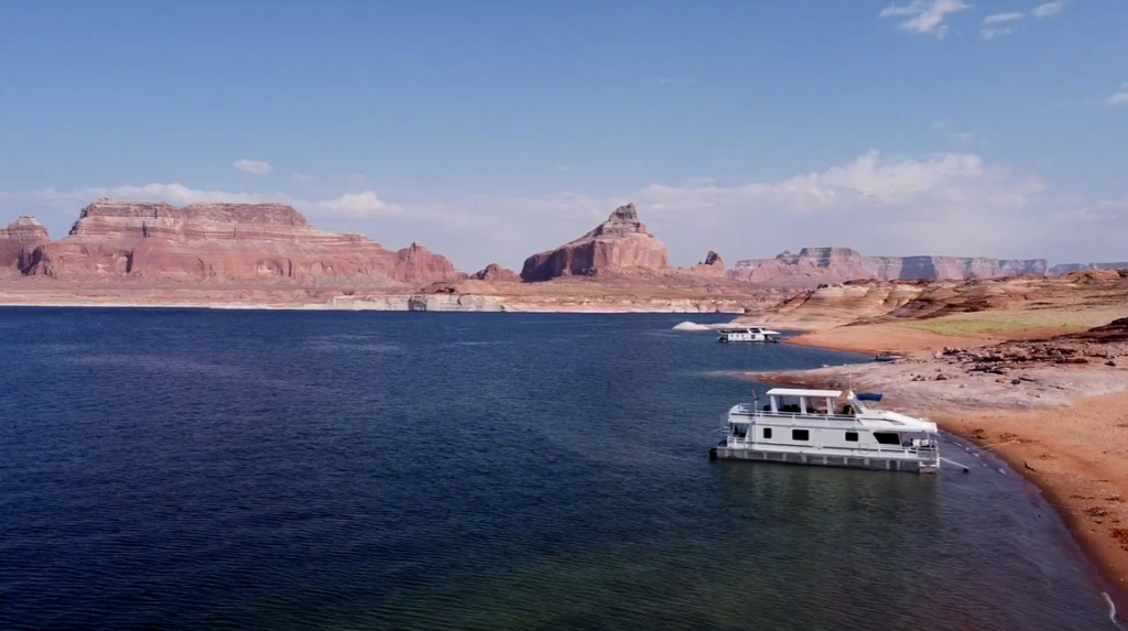
Boating and Houseboating
Boating is the heart of recreation at Lake Powell. The lake’s vast size and winding canyon system make it ideal for powerboating, pontoon boating, and jet skiing. Houseboating is especially popular, allowing visitors to travel deep into remote canyons and anchor along sandy beaches for overnight stays. Marinas such as Wahweap, Antelope Point, Bullfrog, and Halls Crossing serve as major launch points and rental hubs.
Kayaking and Paddleboarding
For a quieter and more immersive experience, kayaking and paddleboarding are excellent ways to explore Lake Powell. Narrow side canyons, calm waters, and towering sandstone walls create unforgettable paddling routes. These activities are particularly popular in areas near Antelope Canyon, Labyrinth Canyon, and Padre Bay, where motorboat traffic is minimal and scenery is at its best.
Fishing Opportunities
Lake Powell is a premier freshwater fishing destination in the western United States. Anglers regularly target striped bass, smallmouth bass, largemouth bass, walleye, crappie, and channel catfish. Fishing is productive year-round, but spring and fall are especially favored due to comfortable temperatures and active fish populations. Shore fishing is possible in some areas, though boats provide the best access to prime fishing spots.
Swimming and Beach Camping
One of Lake Powell’s most unique features is its abundance of natural sandy beaches. These beaches make swimming easy and enjoyable, particularly during the hot summer months. Many visitors combine swimming with beach camping, anchoring boats directly on the shoreline and setting up camp beneath the canyon walls. This freedom to camp almost anywhere along the lake is a major draw for outdoor enthusiasts.
Water Sports and Recreation
In the lake’s wider and calmer sections, water sports thrive. Wakeboarding, water skiing, tubing, and knee-boarding are common activities, especially near marina areas and open bays. The smooth water conditions during early mornings and evenings are ideal for high-speed recreation.
Hiking and Land-Based Adventures
Beyond the water, Lake Powell offers outstanding hiking opportunities through the Glen Canyon National Recreation Area. Trails range from short scenic walks to challenging desert hikes leading to overlooks, slot canyons, and hidden viewpoints. Hiking routes near Rainbow Bridge National Monument and Glen Canyon Dam are among the most popular.
Sightseeing and Scenic Tours
Lake Powell is home to some of the most iconic natural landmarks in the Southwest. Boat tours to Rainbow Bridge National Monument allow visitors to view one of the world’s largest natural sandstone arches. Scenic airplane and helicopter tours offer aerial views of Horseshoe Bend, Glen Canyon, and the vast canyon network surrounding the lake.
Off-Roading and Desert Exploration
The desert terrain surrounding Lake Powell is well suited for off-road exploration. Guided UTV and ATV tours take visitors across slickrock, sandy washes, and elevated viewpoints overlooking the lake. These tours provide a land-based adventure that complements water recreation.
Stargazing and Photography
Thanks to its remote location and minimal light pollution, Lake Powell is an excellent destination for stargazing and night photography. Clear desert skies reveal brilliant views of the Milky Way, making evening hours just as rewarding as daytime exploration.
| Activity | Description |
|---|---|
| Boating & Houseboating | Houseboats, powerboats, and jet skis are the primary way to explore Lake Powell’s vast canyon-filled shoreline |
| Kayaking & Paddleboarding | Ideal for narrow, scenic canyons such as Antelope Canyon and Labyrinth Canyon |
| Fishing | Popular for smallmouth bass, largemouth bass, walleye, crappie, and channel catfish |
| Water Sports | Wakeboarding, tubing, and knee-boarding are common in wider, calmer sections |
| Swimming & Beach Camping | Sandy beaches and secluded coves allow swimming and shoreline camping |
| Hiking | Includes routes to Rainbow Bridge and trails throughout Glen Canyon National Recreation Area |
| Sightseeing & Tours | Boat tours to Rainbow Bridge, helicopter tours, and scenic flights over Horseshoe Bend |
| Off-Roading (UTV/ATV) | Guided UTV tours and self-guided desert exploration near the lake |
| Golfing | Lake Powell National Golf Course offers desert and lake views |
| Stargazing | Remote location provides excellent dark-sky viewing |
| Major Marinas | Wahweap, Antelope Point, Bullfrog, and Halls Crossing |
Importance of Lake Powell
Lake Powell holds immense importance in the southwestern United States due to its role in water management, power generation, recreation, and environmental balance. Created by the Glen Canyon Dam on the Colorado River, the reservoir is a critical component of the Upper Colorado River Basin and directly supports millions of people across several states.
One of the most significant roles of Lake Powell is water storage and regulation. The lake acts as a massive reservoir that stores water for states such as Utah, Arizona, Colorado, New Mexico, Wyoming, Nevada, and California. By capturing seasonal snowmelt and regulating downstream flows, Lake Powell helps ensure a reliable water supply for municipal use, agriculture, and industry in an otherwise arid region. This controlled release of water is essential for meeting interstate water-sharing agreements and maintaining stability in the Colorado River system.
Lake Powell is also vital for hydroelectric power generation. The Glen Canyon Dam produces electricity for communities across the Southwest, providing a renewable energy source that helps reduce reliance on fossil fuels. This hydropower supports homes, businesses, and infrastructure, especially during periods of high energy demand, making Lake Powell an important contributor to regional energy security.
Beyond its economic and infrastructural value, Lake Powell plays a key role in recreation and tourism. The reservoir attracts millions of visitors each year for boating, fishing, kayaking, swimming, and sightseeing. Tourism related to Lake Powell supports local economies in northern Arizona and southern Utah, generating jobs and revenue for nearby towns, marinas, and service providers. Recreational use also promotes outdoor engagement and appreciation of the region’s unique desert landscapes.
Environmentally, Lake Powell contributes to habitat creation in a harsh desert environment. While it is an artificial reservoir, it supports diverse fish populations and provides water sources for birds and wildlife along its shoreline and surrounding canyons. The lake also helps manage sediment that would otherwise accumulate downstream, influencing river ecology and flood control.
Lake Powell is additionally important for flood mitigation and drought management. During periods of heavy snowmelt or rainfall, the reservoir reduces the risk of flooding along the Colorado River. During droughts, stored water helps buffer shortages, although prolonged low water levels have highlighted the lake’s vulnerability and the growing challenges of climate change and water demand.
Famous Ships Sunk in Lake Powell
Lake Powell is not widely known for historic shipwrecks in the traditional sense, but it does have a small number of modern sunken vessels that reflect the lake’s challenging and sometimes unpredictable conditions. As a deep, steep-walled reservoir carved through narrow canyons, Lake Powell can quickly shift from calm to dangerous, especially when sudden desert storms roll through the region.
The most notable and widely reported vessel to sink in Lake Powell is The Knockers, a 105-foot luxury houseboat that went down in July 2022 near Antelope Point Marina. The multi-million-dollar vessel, which featured high-end amenities and even a rooftop helipad, sank during an intense storm marked by strong, unexpected winds. The houseboat settled in a section of the lake estimated to be around 250 feet deep, making recovery extremely difficult and drawing national attention due to the boat’s size and uniqueness.
Aside from this high-profile incident, several smaller, privately owned boats and watercraft are believed to have sunk in Lake Powell over the years. These vessels are largely undocumented and unnamed, often disappearing into deep channels that can exceed 500 feet in depth. The lake’s rocky bottom, steep underwater drop-offs, and constantly fluctuating water levels mean that once a boat sinks, it is rarely visible again and is usually impractical to retrieve.
Unpredictable wind is one of the greatest risk factors for boating accidents on Lake Powell. Strong gusts can funnel through narrow canyons with little warning, creating sudden waves and hazardous conditions even for experienced boaters. These environmental factors, combined with the lake’s immense size and depth, explain why Lake Powell has a reputation for being both breathtakingly beautiful and deceptively dangerous.
Scary Facts About Lake Powell
| Scary Fact | Explanation |
|---|---|
| Sudden Dangerous Winds | Lake Powell is notorious for sudden, powerful wind storms that can appear without warning, creating large waves in narrow canyons and endangering boats. |
| Extreme Water Depth | Parts of the lake exceed 500 feet in depth, making rescues, recoveries, and visibility extremely difficult if accidents occur. |
| Steep Underwater Drop-Offs | The lake’s canyon walls continue underwater, causing sudden depth changes that pose risks for swimmers and boaters. |
| Modern Shipwrecks | Several boats, including a famous luxury houseboat, have sunk due to storms, with many resting unrecovered on the lake bottom. |
| Cold Water Shock | Even in summer, deeper water remains cold, increasing the risk of cold-water shock and rapid fatigue for swimmers. |
| Flash Floods in Side Canyons | Slot canyons feeding the lake can experience sudden flash floods, trapping kayakers or hikers with little escape time. |
| Limited Emergency Access | Many areas are remote, with limited cell service, making emergency response slow or difficult. |
| Rapidly Changing Water Levels | Water levels can drop or rise significantly, exposing hazards or stranding boats and campers. |
| Hidden Submerged Hazards | Old rock formations, debris, and submerged canyon features are often invisible beneath the surface. |
| Extreme Heat Exposure | Summer temperatures frequently exceed 100°F (38°C), increasing the risk of heat exhaustion and dehydration. |
Quick Facts About Lake Powell
| Fact | Details |
|---|---|
| Location | United States (Utah and Arizona) |
| Type | Artificial reservoir |
| River | Colorado River |
| Dam | Glen Canyon Dam |
| Year Created | 1963 (dam completed) |
| Surface Area | ~161,390 acres (252 sq mi) at full pool |
| Water Capacity | ~26–27 million acre-feet |
| Length | ~186 miles (299 km) |
| Shoreline | ~1,960+ miles |
| Maximum Depth | ~560–583 feet near the dam |
| Elevation (Full Pool) | ~3,700 feet above sea level |
| Main City / Hub | Page, Arizona |
| Managed By | U.S. Bureau of Reclamation |
| Recreation Area | Glen Canyon National Recreation Area |
| Popular Activities | Boating, houseboating, kayaking, fishing, hiking |
| Famous Landmark Nearby | Rainbow Bridge National Monument |
| Climate | Arid desert climate |
| Best Time to Visit | Spring and fall |
| Notable Feature | Deep sandstone canyons and red-rock scenery |
Frequently Asked Questions About Lake Powell
Q. Where is Lake Powell? / What state is Lake Powell in?
A. Lake Powell is located on the Utah–Arizona border, with most of the lake in southern Utah and a smaller portion in northern Arizona, near Page, Arizona.
Q. When was Lake Powell made? / When was Lake Powell created?
A. Lake Powell was created in 1966 after the completion of Glen Canyon Dam.
Q. How big is Lake Powell?
A. Lake Powell has a surface area of about 161,390 acres (approximately 252 square miles / 653 square kilometers) at full capacity.
Q. How deep is Lake Powell?
A. Lake Powell has a maximum depth of about 560 feet (170 meters).
Q. What river feeds Lake Powell? / Where does Lake Powell get its water?
A. Lake Powell is primarily fed by the Colorado River.
Q. What to do at Lake Powell?
A. Popular activities at Lake Powell include boating, houseboating, kayaking, fishing, swimming, hiking, camping, and water sports.
Q. Why is Lake Powell so famous? / What is so great about Lake Powell?
A. Lake Powell is known for its stunning canyon landscapes, red rock scenery, boating and houseboating, recreation opportunities, and its role as a major Colorado River reservoir.