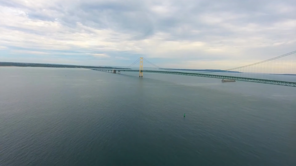
The Great Salt Lake is the largest saltwater lake in the Western Hemisphere and the largest lake in the U.S. outside of the Great Lakes (Superior, Michigan, Huron, Erie, and Ontario). It is a remnant of Lake Bonneville, a prehistoric freshwater lake that once covered a large portion of western Utah.
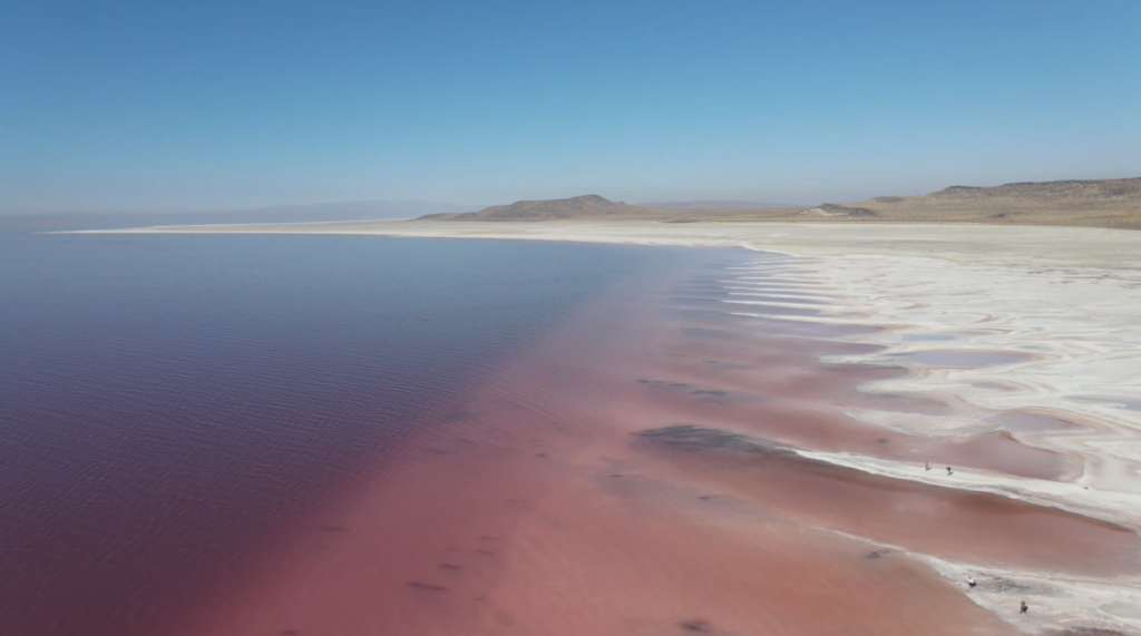
The lake is known for its high salinity, which is much saltier than that of the ocean. The high salinity is due to the lake having no outlet; water flows into the lake but does not flow out, leading to the accumulation of salts. Despite its high salinity, the lake supports a unique ecosystem of microorganisms, brine shrimp, and brine flies. These organisms, in turn, provide food for a variety of bird species, making the lake an important habitat for migratory birds.
The lake has been a source of minerals, including salt and various brines. In the past, salt extraction was a significant industry, and the lake remains an important source of industrial minerals. The lake has several islands, with Antelope Island being the largest. Antelope Island State Park is a popular destination for wildlife viewing, hiking, and other outdoor activities.
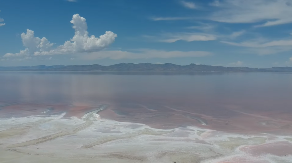
Table of Contents
Location of Great Salt Lake: Country, State, Counties, Cities
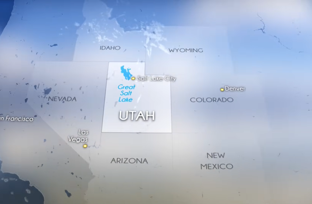
The Great Salt Lake is located in the northern part of the U.S. state of Utah. It lies west of the Wasatch Mountains and north of the Salt Lake Valley, stretching across several counties, including Salt Lake, Davis, Weber, and Tooele. The lake is situated near major cities such as Salt Lake City, Ogden, and Layton, making it easily accessible for visitors. Its vast size and changing shoreline influence the surrounding landscape, creating a unique natural landmark in the heart of Utah.
| Feature | Details |
|---|---|
| Country | United States |
| State | Utah |
| Counties | Salt Lake, Davis, Weber, Tooele |
| Nearby Major Cities | Salt Lake City, Ogden, Layton, West Valley City |
| Geographical Reference | West of the Wasatch Mountains, north of the Salt Lake Valley |
Size of Great Salt Lake: Surface Area, Volume, Length, Width, Shoreline, Depth
The Great Salt Lake is a vast and ever-changing body of water in northern Utah.
| Feature | Details |
|---|---|
| Surface Area | ~1,700 sq mi (4,400 km²), varies with water levels |
| Volume | ~18–20 million acre-feet, depending on lake level |
| Length | ~75 miles (121 km) |
| Width | ~35 miles (56 km) at its widest point |
| Shoreline | ~1,700 miles (2,735 km), including bays, inlets, and islands |
| Average Depth | ~16 feet (5 meters) |
| Maximum Depth | ~33 feet (10 meters) |
Surface Area of Great Salt Lake
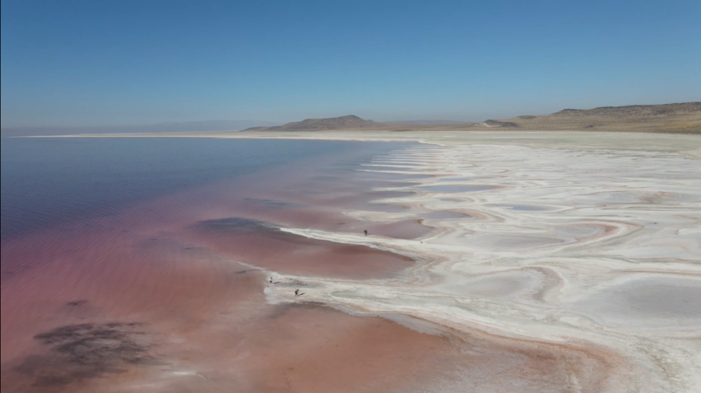
The Great Salt Lake covers an area of about 1,700 square miles (4,400 square kilometers), making it the largest saltwater lake in the Western Hemisphere. However, its size is not constant, as water levels fluctuate with seasonal rainfall, snowmelt, and evaporation. These changes can dramatically alter the lake’s shoreline and exposed salt flats.
Volume of Great Salt Lake
Due to its relatively shallow depth, the volume of the lake is modest compared to its surface area. The lake holds approximately 18–20 million acre-feet of water, though this varies significantly depending on the water level each year.
Maximum Length of Great Salt Lake
The lake stretches roughly 75 miles (121 kilometers) from east to west, making it a vast expanse of water visible from surrounding mountains. Its length allows for diverse habitats and recreational areas along its shores.
Maximum Width of Great Salt Lake
At its widest point, the Great Salt Lake spans about 35 miles (56 kilometers), creating large open-water areas and extensive shallow regions that form its iconic salt flats.
Shoreline Length of Great Salt Lake
The lake’s shoreline measures around 1,700 miles (2,735 kilometers) when including its numerous bays, inlets, and islands. The fluctuating water levels constantly reshape the shoreline, revealing new areas of salt flats and wetlands each year.
Depth of Great Salt Lake
Despite its vast size, the lake is relatively shallow, with an average depth of 16 feet (5 meters) and a maximum depth of about 33 feet (10 meters). Its shallow nature contributes to the high salinity and the formation of the expansive salt flats that surround it.
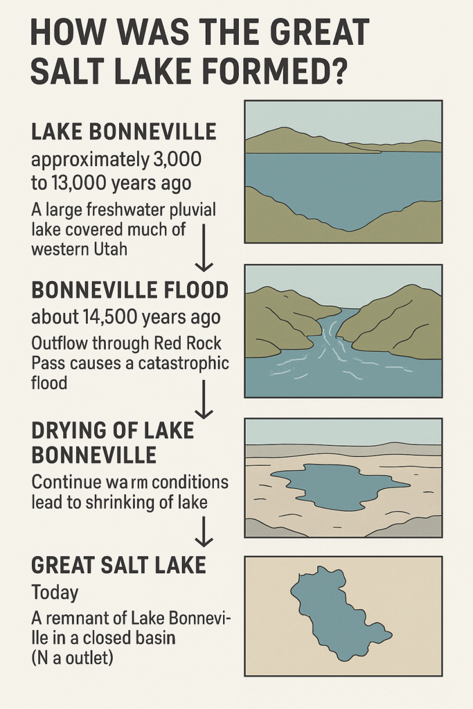
Formation of Great Salt Lake
The Great Salt Lake is a remnant of a much larger prehistoric lake called Lake Bonneville, which existed during the last Ice Age, roughly 14,000 to 30,000 years ago. Lake Bonneville was a massive freshwater lake that once covered a significant portion of western Utah, extending over 20,000 square miles—far larger than the Great Salt Lake today.
As the climate warmed and glaciers melted, Lake Bonneville began to shrink due to evaporation and reduced water inflow, leaving behind smaller bodies of water, including the Great Salt Lake. Unlike most lakes, the Great Salt Lake has no natural outlet, meaning water flows in from rivers like the Bear, Weber, and Jordan, but does not flow out. Over time, this caused salts and minerals to accumulate, giving the lake its famous high salinity.
The lake’s fluctuating water levels and unique formation created vast salt flats, islands, and wetlands, providing habitats for a wide range of wildlife. Today, the Great Salt Lake stands as a living reminder of Lake Bonneville, offering both a glimpse into the region’s geological past and an essential ecosystem for birds, brine shrimp, and other species.
History of Great Salt Lake
The Great Salt Lake has a rich and varied history, dating back thousands of years. Long before European settlers arrived, the region was inhabited by Native American tribes, including the Shoshone, Ute, and Goshute, who relied on the lake and its surrounding wetlands for food, minerals, and trade. Brine shrimp, migratory birds, and salt deposits were important resources for these communities.
In 1824, the lake was first recorded by European explorers when Jedediah Smith, a fur trapper, reached its shores. Over the following decades, the Great Salt Lake became an important landmark for pioneers traveling west, especially members of the Mormon pioneers, who settled in the Salt Lake Valley in 1847. The lake influenced settlement patterns, trade routes, and the development of nearby Salt Lake City.
During the late 19th and early 20th centuries, the Great Salt Lake became a source of industrial minerals, particularly salt, magnesium, and other brines, fueling local industry. Its unique ecosystem and striking landscapes also began attracting visitors, scientists, and naturalists interested in its wildlife and geological features.
In recent decades, the lake has faced challenges from drought, water diversion, and climate change, leading to historically low water levels in the 21st century. Despite these threats, the Great Salt Lake remains a cultural, ecological, and economic landmark, reflecting both the history of human settlement in Utah and the natural story of the American West.
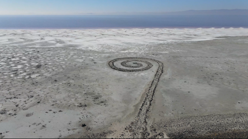
Spiral Jetty at the Great Salt Lake
The Spiral Jetty is one of the most iconic works of land art in the United States, created by artist Robert Smithson in 1970. Located on the northern shore of the Great Salt Lake near Rozel Point, Utah, the artwork is made from basalt rocks, mud, and salt crystals arranged in a 1,500-foot-long coil that extends into the lake.
Major Rivers Feeding Great Salt Lake
The Great Salt Lake is a terminal lake, meaning it has no natural outlet. Water enters the lake primarily through three major rivers: the Bear, Weber, and Jordan. Together with smaller streams, these rivers contribute roughly 70% of the lake’s total inflow, carrying snowmelt from the Wasatch Range and Uinta Mountains into the lake’s endorheic basin.
The Bear River is the largest tributary, supplying about 40–60% of the lake’s water. The Weber River enters from the east, while the Jordan River flows southward from Utah Lake into the southern portion of the Great Salt Lake. The Ogden River is sometimes considered alongside the Weber River as an important contributor.
In addition to these rivers, the lake receives water from internal springs, including sub-lacustrine and shoreline springs, as well as direct precipitation in the form of rain and snow falling onto the lake surface. Because the lake has no outlet, water leaves only through evaporation, which concentrates salts and minerals, giving the Great Salt Lake its remarkably high salinity.
| Water Source | Details |
|---|---|
| Bear River | Largest tributary; provides 40–60% of the lake’s inflow |
| Weber River | Enters from the east; significant source of water and snowmelt |
| Jordan River | Flows from Utah Lake into the southern part of the lake |
| Ogden River | Often considered alongside the Weber River as a key contributor |
| Internal Springs | Includes sub-lacustrine and shoreline springs feeding the lake |
| Direct Precipitation | Rain and snow falling directly onto the lake surface |
| Outflow | None; water leaves only through evaporation, causing high salinity |
Islands of the Great Salt Lake
The Great Salt Lake has 17 officially named islands, though their number and size fluctuate with changing water levels. During periods of low water, some islands can become connected to the mainland, effectively turning into peninsulas. Key islands include Antelope, Gunnison, Fremont, and Stansbury, with Antelope Island being the largest at over 28,000 acres, connected to the mainland by a 7.2-mile causeway.
Antelope Island is home to Antelope Island State Park, offering visitors opportunities to see free-ranging herds of American bison, pronghorn, and bighorn sheep, along with hiking, biking, and camping. Gunnison Island, in the northern arm of the lake, is remote and uninhabited, serving as a critical nesting site for over 10,000 American white pelicans. Fremont Island, the third-largest, has a history of ranching, while Stansbury Island features rugged terrain and is often connected to the mainland during low water. Other smaller islands include Badger, Carrington, Cub, Dolphin, Egg, and Hat.
The islands are ecologically important, providing predator-free habitats for migratory birds and supporting diverse wildlife like bighorn sheep, coyotes, and California gulls. However, due to declining water levels, many islands are increasingly merging with the mainland. Antelope Island remains the only island with direct public access, while other islands are monitored for conservation and research purposes to understand the lake’s changing dynamics.
| Island | Size / Notes | Wildlife / Features | Access / Status |
|---|---|---|---|
| Antelope Island | Largest (~28,000 acres) | American bison, pronghorn, bighorn sheep | State park; 7.2-mile causeway |
| Gunnison Island | Remote, northern arm | Nesting site for 10,000+ American white pelicans | Uninhabited, restricted for conservation |
| Fremont Island | Third-largest | History of ranching | Limited access; privately managed |
| Stansbury Island | Often connected to mainland | Rugged terrain | Limited public access |
Temperature of Great Salt Lake
The Great Salt Lake experiences wide temperature variations throughout the year due to its location in northern Utah’s desert and mountain climate. Summer temperatures often range from 70°F to 90°F (21°C to 32°C), with surface water temperatures reaching their peak in July and August, making the lake warm enough for boating and floating.
In winter, the lake cools significantly, with air temperatures often dropping below 30°F (-1°C) and water temperatures hovering around 40°F (4–5°C). While the lake rarely freezes entirely due to its high salinity, smaller bays and shallow areas can develop ice during particularly cold periods.
Seasonal fluctuations in water level and salinity also affect the lake’s temperature. Shallow areas heat up faster in summer and cool faster in winter, while deeper sections maintain slightly more stable temperatures. These conditions create a unique environment that influences wildlife, brine shrimp reproduction, and the timing of migratory birds visiting the lake.
Seasonal Temperature Pattern of Great Salt Lake
| Season | Air Temperature | Water Temperature | Notes / Effects |
|---|---|---|---|
| Spring (Mar–May) | 45–70°F (7–21°C) | 45–60°F (7–16°C) | Snowmelt increases inflow; lake begins warming; brine shrimp hatch in shallow areas |
| Summer (Jun–Aug) | 70–90°F (21–32°C) | 70–80°F (21–27°C) | Warmest period; ideal for boating and floating; shallow areas heat faster |
| Fall (Sep–Nov) | 50–75°F (10–24°C) | 60–70°F (16–21°C) | Cooling begins; water still warm; migratory birds arrive for fall stopover |
| Winter (Dec–Feb) | 20–40°F (-7–4°C) | 40–45°F (4–7°C) | Coldest period; shallow areas may freeze; high salinity prevents full lake freeze |
Month-Wise Surface Temperature of Great Salt Lake
| Month | Average Surface Temperature (°F / °C) | Notes / Seasonal Effect |
|---|---|---|
| January | 40°F (4°C) | Coldest month; shallow areas may freeze |
| February | 40°F (4°C) | Cold; ice possible in shallow bays |
| March | 45°F (7°C) | Snowmelt begins warming inflows |
| April | 50°F (10°C) | Lake warms gradually; spring migratory birds arrive |
| May | 60°F (16°C) | Shallow areas heat up; brine shrimp hatch |
| June | 70°F (21°C) | Ideal for boating and recreation |
| July | 75°F (24°C) | Warmest water temperatures; peak floating season |
| August | 75°F (24°C) | Water remains warm; bird activity high |
| September | 70°F (21°C) | Cooling begins; fall migration starts |
| October | 60°F (16°C) | Water cools; fewer recreational visitors |
| November | 50°F (10°C) | Cold returns; lake begins winter conditions |
| December | 40°F (4°C) | Cold; high salinity prevents full freeze |
Wildlife in and Ecosystem of the Great Salt Lake
The Great Salt Lake hosts a remarkable and unique ecosystem adapted to its hypersaline waters. Life in the lake is dominated by extremophiles, organisms that thrive in high-salt environments, forming the base of the food web. Brine shrimp (Artemia) and brine flies exist in the billions, while newly discovered nematodes (roundworms) add to the diversity of life. Microorganisms like bacteria and archaea flourish in these conditions, supporting the entire aquatic ecosystem.
The lake is also a critical stopover for millions of migratory birds, including American White Pelicans, Eared Grebes, Wilson’s Phalaropes, and various gulls and shorebirds. Raptors such as Bald Eagles and Peregrine Falcons hunt in the area, taking advantage of the abundant bird populations.
Surrounding the lake, terrestrial mammals such as bison, bighorn sheep, and black bears inhabit the islands and marshlands, while other invertebrates, like the Beewolf wasp, form part of the broader ecosystem.
Animals in Great Salt Lake
| Category | Examples / Details | Role in Ecosystem |
|---|---|---|
| In the Water (Hypersaline) | Brine Shrimp (Artemia), Brine Flies, Nematodes, Microorganisms (bacteria, archaea, phytoplankton) | Form the base of the food web; feed migratory birds |
| Around the Lake (Marshes & Shorelines) | American White Pelicans, Eared Grebes, Wilson’s Phalaropes, gulls, shorebirds, Bald Eagles, Peregrine Falcons | Use lake as migratory stopover; predators feed on fish, birds, and invertebrates |
| Terrestrial & Near-Lake Animals | Bison, Bighorn Sheep, Black Bears, Beewolf wasps | Inhabit islands and surrounding areas; maintain ecological balance |
Fish Found in Great Salt Lake
The Great Salt Lake is famous for its extreme salinity, which makes it one of the few places in the world where traditional freshwater fish cannot survive in the main body of the lake. The high salt content creates a harsh environment that is instead dominated by brine shrimp, brine flies, nematodes, and microorganisms, which form the base of the lake’s unique ecosystem and provide food for millions of migratory birds.
While the lake itself is too salty for most fish, some species survive in freshwater areas connected to the lake, such as ponds, marshes, and streams where salinity is lower. Common carp are found in these inflows and shallow freshwater pockets, thriving in lower-salinity zones. Similarly, rainbow trout and the endangered least chub inhabit nearby freshwater springs and streams feeding into the lake. In addition, bass species can sometimes be found in managed ponds like the I-80 bass ponds, which maintain suitable freshwater conditions.
The presence of these fish is highly dependent on water quality, salinity, and lake levels. During droughts or periods of low water, salinity in smaller tributaries and ponds can rise, limiting fish survival. Pollution and human activity can also affect these sensitive habitats. Because of these limitations, most traditional fishing does not occur in the Great Salt Lake itself. Anglers looking for more typical fishing experiences are better off exploring nearby rivers and reservoirs, including the Jordan, Weber, and Ogden Rivers, which offer abundant freshwater fish.
Aquatic Plants of the Great Salt Lake
The Great Salt Lake is an extreme environment, with salinity levels too high for most vascular plants to survive in the open water. However, the shorelines and surrounding marshes support a variety of salt-tolerant species that thrive in the saline soils. Common plants include salt grass and pickleweed, which form dense complexes along the lake edges. In marshy areas, species like alkali bulrush, Olney three-square bulrush, and Phragmites australis (common reed) flourish, providing important cover and habitat for birds and small animals.
In the open lake itself, the primary aquatic vegetation consists of algae, which thrive in hypersaline conditions and serve as the main food source for brine shrimp and brine flies. Additionally, the lake’s bottom is home to microbialites, reef-like structures made of microbes, which create microhabitats for small organisms and contribute to the lake’s unique ecosystem. While the lake remains too salty for submerged aquatic plants, the surrounding wetlands and marshes play a critical role in supporting migratory birds and other wildlife.
| Plant / Organism | Habitat | Role / Notes |
|---|---|---|
| Salt Grass | Shorelines, saline soils | Forms dense complexes; tolerates high salinity |
| Pickleweed | Shorelines, mudflats | Salt-tolerant; supports marsh ecosystems |
| Alkali Bulrush | Marshes, wetlands | Provides cover and habitat for birds |
| Olney Three-Square Bulrush | Marshes | Common in wetland areas; salt-tolerant |
| Phragmites (Common Reed) | Brackish, shoreline marshes | Thrives in slightly salty water; provides habitat for wildlife |
| Algae | Open lake water | Base of food web; feeds brine shrimp and brine flies |
| Microbialites | Lake bottom | Reef-like microbial structures; habitat for small organisms |
Famous Ships Sunk in Great Salt Lake
Despite being a landlocked, hypersaline lake, the Great Salt Lake has a fascinating maritime history dating back to the 19th century. In the 1800s, the lake was used for transporting salt, livestock, and construction materials for Utah’s early industry, including the transcontinental railroad, which led to numerous small vessels navigating its waters. Many of these industrial and transport boats were lost to the lake, creating a number of shipwrecks, most of which remain unmarked and unnamed.
The most famous shipwreck is the Timely Goal, an 1850s vessel commissioned by Brigham Young. Originally intended to be a horse-powered paddle wheel boat, it was later converted into a sailboat due to high costs. Unfortunately, the Timely Goal broke free from its dock, filled with water, and sank, leaving behind a historic remnant of Utah’s early maritime efforts.
Today, as the lake’s water levels fluctuate and recede, some of these 19th-century shipwrecks become partially visible, providing a unique glimpse into the region’s past. While the Great Salt Lake never hosted large naval battles, its industrial and transport vessels are a testament to the ingenuity and challenges of early settlers navigating this harsh, saline environment.
| Ship / Vessel | Era | Purpose / Notes | Status / Visibility |
|---|---|---|---|
| Timely Goal | 1850s | Originally intended as a horse-powered paddle wheel boat; converted to a sailboat; owned by Brigham Young | Sank after breaking free from dock; partially visible when water levels drop |
| Unnamed Industrial Vessels | 19th century | Used for transporting salt, livestock, and materials for the transcontinental railroad | Many remain underwater; occasionally exposed during low water |
| Small Barges and Transport Boats | 19th century | Early industry and local transport | Most are lost to history; some remnants visible in receding areas |
Why is the Great Salt Lake salty?
The Great Salt Lake is extremely salty because it is a terminal, endorheic lake, meaning that water flows into the lake but has no natural outlet to rivers or the ocean. Rivers such as the Bear, Weber, and Jordan bring in freshwater, carrying dissolved minerals and salts from the surrounding mountains and soil.
As water evaporates from the lake’s surface, it leaves these minerals behind. Over thousands of years, this process has caused the lake’s salinity to increase dramatically, making it several times saltier than the ocean. The lake’s high evaporation rate, shallow depth, and limited inflow all contribute to its hypersaline conditions.
The salty environment creates a unique ecosystem that few organisms can tolerate. While most fish cannot survive in the main lake, brine shrimp, brine flies, and certain microbes thrive, forming the foundation of the food web that supports millions of migratory birds.
Why is the Great Salt Lake drying up?
The Great Salt Lake is experiencing historically low water levels, and scientists warn that it could continue shrinking if current trends persist. The main reasons for the lake’s decline are drought, water diversion, and climate change.
Drought in the western United States, especially in Utah, has reduced the amount of snowpack in the Wasatch and Uinta Mountains, which supply the lake via rivers like the Bear, Weber, and Jordan. Less snow means less runoff entering the lake during spring and summer, lowering its water levels.
Water diversion is another major factor. Rivers that feed the lake are heavily used for agriculture, urban development, and industry. Cities like Salt Lake City and surrounding communities rely on these water sources, as do farms in northern Utah, reducing the inflow to the lake.
Climate change exacerbates both drought and evaporation. Rising temperatures increase the rate of evaporation from the lake’s surface, while hotter, drier conditions reduce snow accumulation in the mountains. The combination of less inflow and more evaporation creates a dangerous imbalance, shrinking the lake and exposing large portions of its lakebed.
When will the Great Salt Lake dry up?/How long until the Great Salt Lake dries up?
The exact timeline for the Great Salt Lake drying up is uncertain, as it depends on several factors including water inflow from rivers, precipitation, and climate change impacts. Scientists warn that if current trends continue—reduced snowpack, ongoing drought, and water diversion for agriculture and cities—the lake could see significant sections of its lakebed exposed within the next few decades.
Recent studies indicate that without major conservation measures, parts of the lake may effectively disappear by mid-21st century. However, this does not necessarily mean the entire lake will vanish overnight; instead, water levels are expected to fluctuate seasonally and annually, with exposed lakebeds increasing during dry periods.
Experts emphasize that human intervention can slow or mitigate the decline, such as reducing water diversion, improving water efficiency, and preserving snowpack runoff. While an exact date is impossible to predict, the lake is in serious decline now, and urgent action is needed to prevent further ecological and economic damage.
What happens if the Great Salt Lake dries up?
If the Great Salt Lake were to dry up, the consequences would be ecological, economic, and health-related. The lake is a critical habitat for millions of migratory birds, including American White Pelicans, Wilson’s Phalaropes, and Eared Grebes. Without the lake, these birds would lose a primary food source, disrupting bird migration and breeding patterns across North America.
The drying lake would also expose vast areas of lakebed sediments, which contain toxic dust, arsenic, and other minerals. Winds can lift this dust into surrounding communities, causing air pollution, respiratory problems, and other health risks for residents of Salt Lake City and northern Utah.
Economically, the lake supports industries such as mineral extraction (salt, magnesium, and brine) and tourism. A dried-up lake would halt mineral production and impact recreational activities like boating, birdwatching, and wildlife tourism.
Finally, the loss of the lake would affect the local climate, as large water bodies help moderate temperature and humidity. Without it, the region could experience hotter summers, colder winters, and increased drought severity, further stressing agriculture, water resources, and local ecosystems.
How to save the Great Salt Lake?
Saving the Great Salt Lake requires a combination of water conservation, habitat protection, and policy action. One of the most important steps is to reduce water diversion from the rivers that feed the lake, including the Bear, Weber, and Jordan Rivers, which are heavily used for agriculture, urban needs, and industry.
Improving water-use efficiency in cities and farms, such as implementing drip irrigation, low-flow systems, and smart water management, can ensure that more water reaches the lake. Protecting the snowpack and surrounding watersheds is also critical, as melting snow provides the majority of the lake’s inflow each year.
Restoring and expanding wetlands and marshes around the lake can help maintain habitat for migratory birds and buffer the ecosystem against low water levels. Coordinated policy efforts and collaboration among state agencies, local governments, farmers, and conservation groups are necessary to prioritize lake water levels and limit over-extraction.
Finally, raising public awareness about the lake’s importance for wildlife, recreation, air quality, and the economy can encourage community support for conservation initiatives. While climate change and prolonged drought make the lake’s future uncertain, immediate and sustained action can help preserve this unique ecosystem for generations to come.
Importance of Great Salt Lake
The Great Salt Lake is ecologically invaluable, serving as a critical habitat for millions of migratory birds each year. Species such as American White Pelicans, Wilson’s Phalaropes, and Eared Grebes rely on the lake for feeding and nesting during their long migratory journeys. Its unique hypersaline ecosystem supports brine shrimp, brine flies, and microbial life, which form the foundation of the food web.
Economically, the lake is a major source of industrial minerals, including salt, magnesium, and other brines used in a variety of industries. Mineral extraction has been a significant part of Utah’s economy for over a century. The lake also attracts tourists and outdoor enthusiasts for activities such as birdwatching, hiking on Antelope Island, sailing, and floating in the buoyant waters.
The Great Salt Lake also plays a role in climate moderation and air quality. Its large surface area helps regulate local temperatures and humidity, while its wetlands act as natural filters for runoff before it reaches the lake. Additionally, the exposed lakebed in a drying lake can create dust storms, so preserving water levels helps protect nearby communities.
Culturally and historically, the lake has been central to Utah’s early settlers, Native American tribes, and industrial development, with shipwrecks and historic landmarks scattered along its shores. Overall, the Great Salt Lake is a unique ecological, economic, and cultural treasure that requires careful management and conservation.
Activity to do at the Great Salt Lake?
The Great Salt Lake offers a variety of recreational and nature-based activities for visitors. One of the most popular experiences is floating in the lake’s buoyant, salty waters, which allows swimmers to effortlessly stay on the surface thanks to the lake’s high salinity. However, the water can feel intense on the skin, so caution is advised.
Birdwatching is another top activity, especially during spring and fall migration, when millions of birds such as American White Pelicans, Wilson’s Phalaropes, and Eared Grebes gather at the lake and surrounding wetlands. The lake’s islands and marshes provide excellent vantage points for photography and wildlife observation.
Hiking and wildlife viewing on Antelope Island State Park, the lake’s largest island, is also a must-do. Visitors can see bison, pronghorn, bighorn sheep, and other wildlife while exploring scenic trails. The island’s beaches and viewpoints offer spectacular sunsets over the lake.
Other popular activities include sailing and boating in areas where water levels are sufficient, as well as exploring the salt flats and mudflats for a unique desert-like experience. Seasonal variations can affect accessibility, so visitors should check water levels and weather before planning activities.
Scary Facts About Great Salt Lake
| Scary Fact / Phenomenon | Details / Explanation |
|---|---|
| Extremely High Salinity | The lake is several times saltier than the ocean, making most freshwater life impossible and creating harsh conditions for humans. |
| Shrinking Water Levels | Historic drought and water diversion have caused record low levels, exposing large areas of lakebed. |
| Toxic Dust from Dry Lakebed | Exposed lake sediments contain arsenic and other minerals; wind can blow them into nearby communities, causing health risks. |
| Unpredictable Weather | Sudden storms and strong winds over the shallow lake can create dangerous conditions for boaters. |
| Hidden Shipwrecks | Receding water levels occasionally reveal old 19th-century vessels, a reminder of past industrial hazards. |
| Fluctuating Islands | Islands can become peninsulas or disappear depending on water levels, making navigation and wildlife patterns unpredictable. |
| Hypersaline Hazards | Swimming in high-salinity water can cause skin and eye irritation, and some areas have extremely hot shallow water in summer. |
Quick Facts About Great Salt Lake
| Category | Fact / Detail |
|---|---|
| Location | Northern Utah, U.S.A.; mainly in Salt Lake County; part of the Great Basin. |
| Major Cities Nearby | Salt Lake City (southeast shore), Ogden (≈10 miles east), West Valley City (southwest of Salt Lake City). |
| Size | 1,700 square miles (4,400 square kilometers), Largest saltwater lake in the Western Hemisphere. |
| Formation | Remnant of prehistoric Lake Bonneville; a terminal, endorheic lake with no natural outlet. |
| Rivers / Tributaries | Bear River (~40–60% inflow), Weber River, Jordan River, Ogden River, smaller streams, springs, and direct precipitation. |
| Salinity | Extremely high; several times saltier than the ocean; fluctuates with water levels. |
| Islands | 17 named islands (e.g., Antelope, Gunnison, Fremont, Stansbury); many fluctuate with water levels; Antelope Island is largest (28,000+ acres). |
| Wildlife (Aquatic) | Brine shrimp (Artemia franciscana), brine flies (Ephydra hians), nematodes, microorganisms (bacteria, archaea, algae). |
| Wildlife (Birds) | Millions of migratory birds: American White Pelicans, Eared Grebes, Wilson’s Phalaropes, gulls, shorebirds; raptors include Bald Eagles and Peregrine Falcons. |
| Wildlife (Terrestrial) | Bison, pronghorn, bighorn sheep, coyotes, black bears, Beewolf wasps. |
| Plants / Vegetation | Salt grass, pickleweed, alkali bulrush, Olney three-square bulrush, Phragmites (common reed), algae, microbialites. |
| Fish | Limited to freshwater inflows: Common Carp, Rainbow Trout, Least Chub, Bass; main lake too salty for most fish. |
| Temperature (Surface) | Seasonal range: Winter: 35–42°F (1.6–5.6°C), Spring: 45–55°F (7–13°C), Summer: 65–75°F (18–24°C), Fall: 50–60°F (10–16°C). |
| Shipwrecks | Timely Goal (1850s, Brigham Young’s sailboat), unnamed industrial vessels, small barges; often revealed by low water. |
| Scary Facts / Hazards | Toxic dust from exposed lakebed, extreme salinity, fluctuating islands, unpredictable storms, skin/eye irritation in water, shrinking water levels. |
| Recreational Activities | Floating in saline waters, birdwatching, hiking on Antelope Island, wildlife viewing, sailing/boating, photography, exploring salt flats. |
| Economic Importance | Mineral extraction (salt, magnesium, brines), tourism, recreation, industrial use. |
| Environmental Threats | Shrinking water levels, drought, climate change, pollution, habitat loss, air quality impacts from dust storms. |
| Conservation Efforts | Reducing water diversion, restoring wetlands, protecting watersheds, improving urban/agricultural water efficiency, policy initiatives, public awareness. |
Frequently Asked Questions About Great Salt Lake
Q. Where is the Great Salt Lake?
A. The Great Salt Lake is in northern Utah, near Salt Lake City, and is the largest saltwater lake in the Western Hemisphere.
Q. The Great Salt Lake is a remnant of which pluvial lake?
A. The Great Salt Lake is a remnant of Lake Bonneville, a prehistoric freshwater lake from the Pleistocene epoch.
Q. How big is the Great Salt Lake?
A. The Great Salt Lake covers about 1,700 square miles, making it the largest saltwater lake in the Western Hemisphere.
Q. How deep is the Great Salt Lake?
A. The lake has an average depth of about 16 feet (4.9 meters) and a maximum depth of 33 feet (10 meters).
Q. What lives in the Great Salt Lake?
A. Despite its high salinity, the Great Salt Lake supports a unique ecosystem including brine shrimp, brine flies, and other microorganisms.
Q. What fish are in the Great Salt Lake?
A. The Great Salt Lake is too salty for most fish, but freshwater streams and ponds feeding into it support species like carp and trout.
Q. How much salt is in the Great Salt Lake?
A. The Great Salt Lake has an average salinity of about 12–15%, much higher than the ocean’s 3.5%.
Q. Why is there arsenic in the Great Salt Lake?
A. Arsenic in the Great Salt Lake comes from naturally occurring sediments in surrounding mountains, which accumulate in the lake due to its lack of an outlet.
Q. Who led the Mormon exodus to the Great Salt Lake?
A. Brigham Young led the mid-19th century Mormon migration to the Great Salt Lake region.
Q. Is the great salt lake freshwater?
A. No, the Great Salt Lake is not freshwater. It is the largest terminal, hypersaline (saltwater) lake in the Western Hemisphere, with salinity levels often 3 to 10 times saltier than the ocean.