Lake Huron is one of the five Great Lakes of North America (Superior, Michigan, Erie, and Ontario) and the second-largest Great Lake by surface area. Located along the U.S.–Canada border, Lake Huron borders the states of Michigan and plays a crucial role in freshwater supply, climate regulation, transportation, and tourism in the United States.
Known for its clear blue waters, thousands of islands, historic shipwrecks, and scenic shoreline, Lake Huron attracts millions of visitors each year. The lake has historical significance, with various lighthouses and maritime heritage sites along its shores. It has played a role in transportation and trade throughout the centuries.
Table of Contents
Location of Lake Huron: Country, States, Cities
Lake Huron is one of the five Great Lakes of North America and is located on the border between the United States and Canada. It is situated to the east of Michigan’s Upper Peninsula. Its central location within the Great Lakes system makes it an important geographic, environmental, and economic feature of the region.
Countries Bordering Lake Huron
Lake Huron is shared by two countries in North America.
| Country | Position Around Lake Huron |
|---|---|
| United States | Western and southern shores |
| Canada | Eastern and northern shores |
U.S. States Bordering Lake Huron
In the United States, Lake Huron borders only one state, but across two major peninsulas.
| U.S. State | Bordering Region |
|---|---|
| Michigan | Eastern Lower Peninsula and eastern Upper Peninsula |
Canadian Province Bordering Lake Huron
On the Canadian side, Lake Huron lies entirely within one province.
| Province | Bordering Region |
|---|---|
| Ontario | Eastern and northeastern shoreline |
Major Cities on Lake Huron
Major Cities on Lake Huron in the United States
Several important U.S. cities and towns are located along Lake Huron’s shoreline, especially in Michigan.
| Place | Location | Key Details |
|---|---|---|
| Port Huron | Southern tip of Lake Huron, Michigan | Located where Lake Huron meets the St. Clair River; known as the “Blue Water Area” |
| Bay City | Eastern Michigan | Situated on the Saginaw River near its mouth on Lake Huron |
| Alpena | Northeast Michigan | Major city on Thunder Bay along Lake Huron |
| Mackinaw City | Northern Michigan | Gateway to the Upper Peninsula and Mackinac Island |
| Oscoda | Northeastern Lower Peninsula, Michigan | Known for sandy beaches and direct Lake Huron access |
| East Tawas | Northeastern Lower Peninsula, Michigan | Popular coastal town with beaches and harbor |
| Port Austin | Tip of Michigan’s “Thumb” region | Scenic shoreline and access to Lake Huron |
| Caseville | Michigan’s “Thumb” region | Known for beaches and summer tourism |
Major Cities on Lake Huron in Canada
Lake Huron also supports key Canadian cities and communities along its coast.
| City / Town | Province | Location on Lake Huron | Key Highlights |
|---|---|---|---|
| Sarnia | Ontario | Southern tip of Lake Huron | Largest Canadian city on the lake; major industrial and shipping hub |
| Saugeen Shores | Ontario | Eastern shoreline | Municipality of Port Elgin and Southampton; known for long sandy beaches and tourism |
| Goderich | Ontario | Eastern shoreline | Historic port town on bluffs; known as “Canada’s Prettiest Town” |
| Bayfield | Ontario | Eastern shoreline | Historic village with heritage harbor and beaches |
| Kincardine | Ontario | Eastern shoreline | Lighthouse town with Scottish heritage and scenic beaches |
| Grand Bend | Ontario | Southeastern shoreline | Major tourist destination famous for wide, busy sandy beaches |
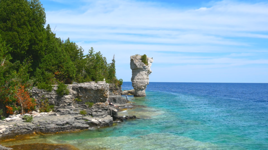
| Tobermory | Ontario | Tip of the Bruce Peninsula | Gateway to Fathom Five National Marine Park and shipwreck diving |
Size of Lake Huron: Surface Area, Volume, Length, Width, Shoreline, Depth
Lake Huron is one of the largest freshwater lakes in the world and a major component of the Great Lakes system. Its immense size influences regional climate, supports commercial navigation, and provides freshwater to millions of people in the United States and Canada.
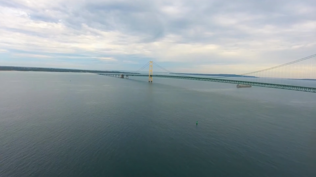
Lake Huron is connected to Lake Michigan through the wide Straits of Mackinac, and together they form the largest freshwater lake system in the world by surface area, making this paired lake system uniquely significant on a global scale.
| Measurement Category | Data |
|---|---|
| Surface Area | 23,010 sq mi (59,600 sq km) |
| Water Volume | 850 cu mi (3,540 cu km) |
| Length | 206 mi (332 km) |
| Maximum Width | 183 mi (295 km) |
| Shoreline Length | 3,827 mi (6,159 km) |
| Average Depth | 195 ft (59 m) |
| Maximum Depth | 750 ft (229 m) |
Surface Area of Lake Huron
Lake Huron covers an expansive surface area of 23,010 square miles (59,600 sq km), ranking it as the second-largest of the Great Lakes by surface area. This vast open water plays a major role in moderating temperatures along the surrounding shoreline, particularly in Michigan, where cooler summers and lake-effect snowfall are strongly influenced by the lake’s size.
Volume of Lake Huron
The lake holds approximately 850 cubic miles (3,540 cubic kilometers) of freshwater. Although Lake Huron is not the deepest of the Great Lakes, its total water volume still places it among the largest freshwater bodies on Earth.
Maximum Length and Width of Lake Huron
Lake Huron extends roughly 206 miles (332 km) from north to south and reaches a maximum width of about 183 miles (295 km). Its broad shape, combined with large bays such as Georgian Bay and Saginaw Bay, gives the lake a complex and highly irregular outline, contributing to its expansive shoreline.
Shoreline Length of Lake Huron
With an estimated shoreline length of 3,827 miles (6,159 km) including islands, Lake Huron has the longest shoreline of all the Great Lakes. This distinction is largely due to the presence of thousands of islands, most notably Manitoulin Island, the largest freshwater island in the world.
Depth of Lake Huron
Lake Huron has an average depth of approximately 195 feet (59 meters) and reaches a maximum depth of around 750 feet (229 meters). These depths allow the lake to support major shipping routes, cold-water fish species, and diverse aquatic ecosystems, while also influencing water temperature and circulation patterns.
Formation and History of Lake Huron
Lake Huron’s formation and history are deeply rooted in ancient geological processes and climatic changes that shaped the Great Lakes region. From powerful glaciers carving its basin to centuries of Indigenous presence and European exploration, Lake Huron has evolved into one of North America’s most important freshwater bodies.
Geological Formation of Lake Huron
Lake Huron was formed during the last Ice Age, approximately 10,000 to 14,000 years ago, as massive continental glaciers advanced and retreated across North America. These glaciers carved deep basins into the underlying bedrock, which consists mainly of limestone, dolomite, and shale. As the ice sheets moved, they scoured the land surface, widened valleys, and deepened depressions that would later fill with meltwater.
When the glaciers began to retreat, enormous volumes of meltwater flowed into these basins, gradually forming the early Great Lakes. Lake Huron’s basin was shaped not only by glacial erosion but also by pre-glacial river valleys that guided the movement of ice and water. The lake’s irregular shape, wide bays, and extensive shoreline are direct results of this complex glacial activity.
Post-Glacial Development
After the glaciers melted, Lake Huron went through several stages of rising and falling water levels as outlets opened and closed due to shifting land and ice dams. During this period, the land surrounding the lake experienced isostatic rebound, a slow uplift of the Earth’s crust following the removal of the immense weight of glacial ice. This ongoing process continues today and subtly alters shorelines, water depths, and drainage patterns.
Over time, Lake Huron became permanently connected to the other Great Lakes. It drains eastward into Lake Erie through the St. Clair River, Lake St. Clair, and the Detroit River, while remaining connected to Lake Michigan through the Straits of Mackinac, together forming the largest freshwater lake system in the world by surface area.
Indigenous History
Long before European contact, Lake Huron was home to Indigenous peoples who relied on its waters for transportation, fishing, and trade. Tribes such as the Huron-Wendat, Ojibwe (Chippewa), Odawa (Ottawa), and Potawatomi lived along the lake’s shores for thousands of years. The lake served as a major travel route and cultural crossroads, linking communities across what is now the United States and Canada.
For Indigenous nations, Lake Huron was not only a source of food and commerce but also a spiritually significant landscape. Fishing, canoe travel, and seasonal settlements were central to life around the lake, and many traditional practices connected directly to its waters.
European Exploration and Settlement
European history on Lake Huron began in the early 17th century when French explorers and missionaries entered the region. In 1615, French explorer Samuel de Champlain became one of the first Europeans to reach the lake, which was later named after the Huron people. French fur traders quickly recognized the lake’s strategic importance as a transportation corridor linking the interior of North America to the Atlantic via the St. Lawrence River.
Throughout the 17th and 18th centuries, Lake Huron played a key role in the fur trade and colonial expansion. Control of the lake shifted between French and British forces, particularly during conflicts such as the French and Indian War. Forts, trading posts, and settlements were established along its shores, shaping early regional development.
Role in Shipping and Industry
During the 19th and early 20th centuries, Lake Huron became a vital route for commercial shipping. The lake supported the transport of iron ore, timber, grain, and other industrial goods between the Midwest and eastern North America. Its connection to the other Great Lakes made it a critical link in one of the world’s busiest inland shipping networks.
The rise of shipping also led to numerous shipwrecks, many of which now rest on the lakebed due to sudden storms, strong winds, and unpredictable weather. Today, Lake Huron is known for having one of the highest concentrations of historic shipwrecks in the Great Lakes.
Major Rivers Feeding Lake Huron
Lake Huron is sustained by a large network of rivers and streams that drain vast areas of the United States and Canada. These rivers supply freshwater, sediments, and nutrients that support the lake’s ecosystems, regulate water levels, and connect inland watersheds to the Great Lakes system. The rivers feeding Lake Huron originate from forests, wetlands, agricultural lands, and upland regions, making them essential to both environmental health and regional hydrology.
Major Rivers Feeding Lake Huron (United States)
In the United States, Lake Huron is primarily fed by rivers flowing through the state of Michigan. These rivers play a key role in supplying freshwater to the lake and supporting fisheries, wetlands, and coastal communities.
| River Name | State | Origin / Drainage Area | Notes |
|---|---|---|---|
| Saginaw River | Michigan | Drains central Michigan via Lake Huron basin | Largest U.S. river system flowing into Lake Huron |
| Thunder Bay River | Michigan | Northern Lower Peninsula | Supports Alpena region and major fisheries |
| Au Sable River | Michigan | Northern Michigan highlands | Known for cold, clear water and trout habitat |
| Cheboygan River | Michigan | Connected to inland lakes | Links Lake Huron with Michigan’s interior waterways |
| Rifle River | Michigan | Northeastern Lower Peninsula | Feeds Saginaw Bay ecosystem |
Major Rivers Feeding Lake Huron (Canada)
On the Canadian side, Lake Huron is fed by several significant rivers flowing through Ontario. These rivers drain large watersheds and contribute to the lake’s water balance and ecological diversity.
| River Name | Province | Origin / Drainage Area | Notes |
|---|---|---|---|
| St. Marys River | Ontario | Connects Lake Superior to Lake Huron | Primary inflow river to Lake Huron |
| Maitland River | Ontario | Southwestern Ontario | Important agricultural drainage river |
| Saugeen River | Ontario | Bruce Peninsula region | Major river supporting wetlands and fisheries |
| French River | Ontario | Drains Lake Nipissing | Historic waterway and major tributary |
| Mississagi River | Ontario | Northern Ontario | Large watershed feeding northern Lake Huron |
Hydrological Importance of These Rivers
The rivers feeding Lake Huron regulate water levels, transport sediments, and sustain coastal wetlands and fish spawning areas. The St. Marys River is especially important, as it delivers water directly from Lake Superior, making it the largest single inflow to Lake Huron. U.S. rivers such as the Saginaw River significantly influence water conditions in Saginaw Bay, one of the lake’s most productive ecological zones.
Together, these rivers form a complex freshwater network that connects inland landscapes to Lake Huron and links the lake to the broader Great Lakes system. Their continued health is critical for maintaining water quality, biodiversity, and the long-term sustainability of Lake Huron.
Islands in Lake Huron
Lake Huron is home to more than 30,000 islands, giving it the longest shoreline of all the Great Lakes and the highest number of islands in the entire system. These islands are spread across Georgian Bay, the North Channel, Saginaw Bay, and the Straits of Mackinac, creating one of the most complex and scenic freshwater coastlines in the world. Many of the islands were formed during the last Ice Age, when retreating glaciers carved the lake basin and left behind rocky outcrops, limestone plateaus, and sandy shorelines that later became islands.
The largest and most significant island in Lake Huron is Manitoulin Island, located in Ontario, Canada. It is the largest freshwater island on Earth and is notable for its dramatic limestone bluffs, forests, Indigenous cultural heritage, and hundreds of inland lakes, some of which contain their own islands. On the U.S. side, Mackinac Island stands out as one of the most famous islands in North America, known for its historic fortifications, preserved Victorian architecture, and strict ban on motor vehicles, which has helped maintain its historic character and strong tourism appeal.
Lake Huron also contains several important island chains and archipelagos. The Les Cheneaux Islands, a group of 36 islands near Michigan’s Upper Peninsula, are especially popular for boating and kayaking and are deeply connected to the region’s maritime traditions. In Canadian waters, the Duck Islands form a small but ecologically important chain southwest of Manitoulin Island. Smaller but historically significant islands such as Charity Island in Saginaw Bay and the Huron Islands wildlife refuge further highlight the lake’s ecological and navigational importance.
Together, the islands of Lake Huron support diverse ecosystems ranging from rocky alvar landscapes to sandy beaches and dense forests. Many islands serve as critical habitats for migratory birds, fish spawning grounds, and protected wildlife areas, making them essential not only for tourism and recreation but also for conservation across the Great Lakes region.
Major Islands and Archipelagos in Lake Huron
| Island / Island Group | Country | Location in Lake Huron | Key Significance |
|---|---|---|---|
| Manitoulin Island | Canada | Northern Lake Huron | World’s largest freshwater island; limestone bluffs, Indigenous heritage, inland lakes |
| Mackinac Island | United States | Straits of Mackinac | Car-free island; historic forts; major tourist destination |
| Les Cheneaux Islands | United States | Near Upper Peninsula, Michigan | 36-island chain; boating, kayaking, wooden boat heritage |
| Duck Islands | Canada | Southwest of Manitoulin Island | Five-island chain; includes Great Duck Island; wildlife importance |
| Charity Island | United States | Saginaw Bay | Historic lighthouse; fishing and maritime history |
| Huron Islands | United States | Northern Lake Huron | Eight-island group; part of a national wildlife refuge |
| Bois Blanc Island | United States | Near Straits of Mackinac | Residential and recreational island close to Mackinac Island |
Temperature of Lake Huron
Lake Huron’s water temperature varies dramatically throughout the year due to its massive size, depth, and northern location. Seasonal changes strongly influence surface conditions, ranging from near-freezing temperatures in winter to pleasant swimming temperatures in summer. Southern areas of the lake, particularly near Port Huron, warm faster and reach higher summer temperatures than the colder northern and offshore waters.
During spring (April–May), Lake Huron slowly emerges from winter conditions as ice melts and sunlight increases. Surface water temperatures generally range between 39°F and 50°F (4°C–10°C), remaining cold enough to pose safety risks despite warming air temperatures. By summer (June–August), surface temperatures rise significantly, frequently reaching 65°F to 75°F (18°C–24°C) by July. In southern and shallow nearshore areas, temperatures can exceed 75°F (24°C), with comfortable swimming conditions often beginning in late June.
In autumn (September–November), Lake Huron begins to cool as air temperatures decline. September surface temperatures typically average between 60°F and 65°F (16°C–18°C) before dropping sharply through October and November. Winter (December–March) brings the coldest conditions, with surface temperatures hovering between 32°F and 36°F (0°C–2°C). Ice formation becomes common in bays and shallow regions, especially in Georgian Bay, while deeper central portions of the lake often remain partially open.
Cold water safety is a critical concern on Lake Huron. Cold shock risk is highest when water temperatures are between 32°F and 60°F (0°C–16°C), a range that persists for much of the year. Even during warmer months, sudden immersion can be dangerous without proper preparation.
Seasonal Water Temperature Ranges of Lake Huron
| Category | Typical Temperature Range |
|---|---|
| Overall Annual Range | 32°F–75°F (0°C–24°C) |
| Spring (April–May) | 39°F–50°F (4°C–10°C) |
| Summer (June–August) | 65°F–75°F (18°C–24°C) |
| Peak Summer (Southern Areas) | Above 75°F (24°C) |
| Autumn (September) | 60°F–65°F (16°C–18°C) |
| Winter (December–March) | 32°F–36°F (0°C–2°C) |
| Cold Shock Risk Zone | 32°F–60°F (0°C–16°C) |
| Ice Formation | Common in shallow bays and Georgian Bay |
Month-Wise Surface Temperature of Lake Huron
The table below shows average surface water temperatures of Lake Huron by month. Actual temperatures may vary depending on location, weather conditions, and depth.
| Month | Average Surface Temperature |
|---|---|
| January | 0–2°C (32–36°F) |
| February | 0–2°C (32–36°F) |
| March | 1–3°C (34–38°F) |
| April | 3–6°C (38–43°F) |
| May | 7–12°C (45–54°F) |
| June | 13–18°C (55–65°F) |
| July | 18–22°C (65–72°F) |
| August | 20–23°C (68–74°F) |
| September | 17–20°C (63–68°F) |
| October | 12–15°C (54–59°F) |
| November | 7–10°C (45–50°F) |
| December | 2–5°C (36–41°F) |
Wildlife in Lake Huron
Lake Huron supports a rich and diverse range of wildlife due to its vast size, varied water depths, extensive shoreline, and thousands of islands. Its ecosystems include open water zones, coastal wetlands, rocky shores, sandy beaches, and forested islands. These habitats allow mammals, birds, fish, and aquatic plants to thrive, making Lake Huron one of the most biologically important lakes in the Great Lakes system.
The lake’s relatively clear and cold waters, combined with protected bays such as Georgian Bay and Saginaw Bay, create ideal conditions for both aquatic and terrestrial species. Wildlife in Lake Huron plays a crucial role in maintaining ecological balance and supporting fisheries and conservation efforts.
Animals in Lake Huron
Lake Huron is home to a wide range of mammals, birds, and reptiles that depend on the lake and its shoreline for food, nesting, and migration.
| Animal | Category | Habitat / Notes |
|---|---|---|
| Lake Whitefish | Mammal (Aquatic) | Keystone species in Lake Huron food web |
| River Otter | Mammal | Coastal wetlands and river mouths |
| Beaver | Mammal | Shorelines and tributaries |
| Bald Eagle | Bird | Nests along shoreline and islands |
| Common Loon | Bird | Open water and quiet bays |
| Herring Gull | Bird | Islands and rocky shores |
| Snapping Turtle | Reptile | Shallow bays and wetlands |
Fish in Lake Huron
Lake Huron supports both cold-water and warm-water fish species. These fish are vital for commercial fishing, sport fishing, and maintaining ecological stability.
| Category | Fish Species | Notes |
|---|---|---|
| Salmon Species | Chinook salmon, Coho salmon, Pink salmon, Atlantic salmon | Widely stocked and naturally reproducing; major sport fish |
| Trout Species | Lake trout, Rainbow trout (steelhead) | Native lake trout populations have recovered through conservation |
| Native Fish | Lake sturgeon | Ancient species; protected due to slow reproduction |
| Popular Sport Fish | Walleye, Smallmouth bass, Northern pike, Muskellunge | Support recreational fishing across the lake |
| Commercial Fish | Lake whitefish, Yellow perch | Important to regional fisheries |
| Other Native Species | Burbot, Cisco (Lake herring) | Cold-water species common in deeper areas |
| Invasive Species | Sea lamprey, Alewife, Round goby | Impact native fish populations and food webs |
Biggest Fish in Lake Huron
Some of the largest freshwater fish species in the Great Lakes can be found in Lake Huron. These species are known for their size, strength, and ecological importance.
| Fish Species | Native / Invasive | Maximum Size | Key Characteristics |
|---|---|---|---|
| Lake Sturgeon | Native | Over 7 ft; 240–300 lbs | Largest fish in Lake Huron; prehistoric species; lifespan up to 150 years |
| Grass Carp | Invasive | Over 58 lbs | Large herbivorous fish; poses ecological concerns |
| Lake Trout | Native | Up to 40 lbs | Cold-water species; important sport and native fish |
| Chinook Salmon | Introduced | Over 30 lbs | Largest salmon species in the lake; popular sport fish |
| Muskellunge | Native | Over 50 lbs | Apex predator; one of the largest freshwater game fish |
Aquatic Plants in Lake Huron
Aquatic plants play a critical role in oxygen production, shoreline stabilization, and providing habitat for fish and invertebrates. Lake Huron contains both native and invasive plant species.
| Category | Plant Species | Habitat & Notes |
|---|---|---|
| Submerged Native Plants | Coontail (Ceratophyllum demersum), Common waterweed (Elodea canadensis), Slender naiad (Najas flexilis), Pondweeds (Potamogeton spp.) | Grow fully underwater; provide fish habitat and oxygen |
| Emergent / Floating Native Plants | Water-celery (Vallisneria americana), Bladderworts (Utricularia spp.), Duckweeds | Common in shallow bays and wetlands; support wildlife |
| Invasive / Non-Native Plants | Phragmites (common reed), Eurasian watermilfoil (Myriophyllum spicatum), Curly-leaf pondweed (Potamogeton crispus), Purple loosestrife (Lythrum salicaria), European frog-bit (Hydrocharis morsus-ranae) | Spread rapidly in nutrient-rich areas; displace native vegetation |
Famous Ships Sunk in Lake Huron
Lake Huron is home to numerous historic shipwrecks, many concentrated in the Thunder Bay area, often called the “graveyard of ships.” This region, near Alpena, Michigan, is part of the Thunder Bay National Marine Sanctuary, which preserves hundreds of sunken vessels and serves as a popular site for diving and maritime history enthusiasts. Lake Huron’s shipwrecks reflect both the dangers of Great Lakes shipping and the rich industrial and commercial history of the region.
One of the most infamous storms to strike Lake Huron was the White Hurricane of 1913, which sank over a dozen ships and caused approximately 250 fatalities. Among the most notable wrecks from this and other periods are the SS Daniel J. Morrell (1966), a 603-foot freighter that broke apart in a storm near Harbor Beach, Michigan, claiming 28 of 29 crew members, and the SS Cedarville (1965), which sank after colliding with a Norwegian freighter in the Straits of Mackinac.
Other famous vessels lost to the lake include the Regina (1913), James Carruthers (1913), SS Pewabic (1865), and the schooner-barge Minnedosa (1905). Many wrecks remain in remarkably preserved condition due to the cold, fresh waters, making Lake Huron a unique underwater museum.
Divers and researchers continue to explore these wrecks, including smaller wooden or iron vessels like the Monohansett (1907) and the Grecian (1906), which tell the story of early shipping, trade, and navigation in the Great Lakes. Recreational diving, historical studies, and maritime tourism keep the memory of these shipwrecks alive, emphasizing both the beauty and the dangers of Lake Huron’s waters.
| Ship Name | Year Sank | Type / Length | Location | Key Details |
|---|---|---|---|---|
| SS Daniel J. Morrell | 1966 | 603-foot freighter | Near Harbor Beach, MI | Broke in two during a storm; 28 of 29 crew died |
| SS Cedarville | 1965 | 604-foot freighter | Straits of Mackinac | Sank after collision with a Norwegian freighter |
| Regina | 1913 | Steel freighter | Lake Huron | Lost with all hands during White Hurricane; discovered in 1986 |
| James Carruthers | 1913 | 529-foot freighter | Lake Huron | Sank during White Hurricane; found upside down in 190 ft of water |
| SS Pewabic | 1865 | Iron-hulled steamer | Lake Huron | Sank after collision with sister ship Meteor; over 100 lives lost |
| Africa | 1895 | Cargo steamer | Near Bruce Peninsula | Sank with all 11 crew during a storm |
| Monohansett | 1907 | Wooden steam barge | Near Thunder Bay Island | Caught fire and sank; now a diving site |
| Grecian | 1906 | Steel propeller-driven | Lake Huron | Sank after hitting a rock |
| Sport | 1920 | Steel tugboat | Near Lexington, MI | First steel-hulled tug on Great Lakes; foundered |
| Minnedosa | 1905 | Schooner-barge | Lake Huron | Sank in a storm while in tow |
Importance of Lake Huron
Lake Huron, the second-largest Great Lake by surface area, is a vital resource for millions of people across Michigan, Ontario, and surrounding areas. Its waters provide drinking water, industrial use, and agricultural support, making it an essential freshwater source. Beyond utility, Lake Huron sustains a robust economy, supporting both commercial and recreational fishing, tourism, and shipping. Its long and complex shoreline, combined with thousands of islands, also makes it a hotspot for ecological diversity, including rare alvar habitats, wetlands, and diverse wildlife species.
The lake has historical and cultural significance as well. It was the first of the Great Lakes to be explored by Europeans, with Samuel de Champlain visiting in 1615, and it holds a rich maritime legacy evident in the numerous shipwrecks preserved in the Thunder Bay National Marine Sanctuary and Fathom Five National Marine Park. Indigenous communities have relied on Lake Huron for centuries, utilizing its waters, fish, and islands for sustenance, transport, and cultural practices.
Lake Huron’s shoreline is the longest of all the Great Lakes, featuring over 30,000 islands, extensive wetlands, and critical breeding grounds for fish and wildlife. The lake’s scenic landmarks, including the Bruce Peninsula, Georgian Bay, and Manitoulin Island, make it a major tourism hub, attracting millions of visitors annually. Shipping, energy production, and freshwater supply further enhance its economic and strategic importance.
However, Lake Huron faces significant environmental challenges, including industrial pollution, runoff, and invasive species such as zebra and quagga mussels, which have altered the native ecosystem. Despite these pressures, ongoing conservation and management efforts continue to protect and sustain the ecological, economic, and cultural value of Lake Huron for generations to come.
Key Aspects of Importance of Lake Huron
| Category | Details |
|---|---|
| Ecological Significance | Hosts unique ecosystems like alvars and wetlands (e.g., Saginaw Bay); provides critical breeding grounds for fish; supports diverse wildlife; longest shoreline of all Great Lakes with 30,000+ islands |
| Economic Impact | Vital shipping route; supports industries; major commercial and recreational fishing hub; tourism hotspot including Bruce Peninsula, Georgian Bay, and Manitoulin Island |
| Resource & Utility | Primary source of drinking water for surrounding communities; used in hydroelectric power generation; supports agriculture and industrial operations |
| Historical & Cultural Significance | First Great Lake explored by Europeans (Samuel de Champlain, 1615); rich maritime history with numerous shipwrecks; home to Indigenous cultures and heritage |
| Environmental Challenges | Susceptible to pollution and industrial runoff; invasive species such as zebra and quagga mussels have altered native ecosystems |
Scary Facts About Lake Huron
Lake Huron is notorious for its treacherous waters and maritime dangers, earning nicknames like the “graveyard of ships” due to the large number of vessels it has claimed over centuries. With over 1,200 known shipwrecks and an estimated 30,000 lives lost since the 1600s, the lake’s history is a reminder of its unpredictable and hazardous nature. The lake’s cold, deep waters have preserved many wrecks in remarkable condition, offering both a haunting glimpse into history and a challenge for modern divers.
Winter brings another hazard in the form of killer ice shelves along the shoreline. These ice formations can appear solid but often hide hollow, unstable cavities underneath. Falling through one of these ice shelves is nearly always fatal, as escaping is extremely difficult. The lake’s size and complexity add to its danger, with over 30,000 islands and the longest shoreline of the Great Lakes, complicating navigation and search-and-rescue operations.
Lake Huron’s storms can also be deadly. The 1996 “Hurroncane”, a rare hurricane-like storm that formed directly over the lake, demonstrated the lake’s potential for violent, unpredictable weather. Other storms throughout history, such as the White Hurricane of 1913, have caused massive loss of life and numerous shipwrecks. Additionally, the lake reaches a maximum depth of 750 feet (229 meters) north of the Bruce Peninsula, providing enough volume and concealment to make navigation and recovery operations difficult.
Even the wildlife poses a threat to fish populations and the lake’s ecosystem. Sea lampreys, parasitic eel-like creatures with suction-cup mouths and razor-sharp teeth, attach to fish and can severely impact fisheries, further emphasizing the lake’s formidable natural challenges.
| Fact Category | Details |
|---|---|
| Sudden Storms | Lake Huron experiences sudden, powerful storms that can produce waves up to 20–30 feet, creating dangerous conditions for ships and boats. |
| Freezing Temperatures | Winter surface waters often reach 32°F (0°C); shallow bays may freeze unevenly, posing risks for travel and ice-related accidents. |
| Shipwrecks | Hundreds of ships have sunk, including famous wrecks like SS Carl D. Bradley, SS Regina, and Kyle Spangler, often due to storms or navigation hazards. |
| Strong Currents | The Straits of Mackinac create dangerous currents and whirlpools, challenging even experienced sailors. |
| Cold Deep Waters | Maximum depth reaches 750 ft (229 m), with extremely cold, dark waters that preserve shipwrecks and can be deadly for swimmers or divers. |
| Historical Disasters | Winter storms, especially the Great Lakes Storm of 1913, caused multiple shipwrecks and significant loss of life. |
| Navigational Hazards | Thousands of islands, reefs, and narrow channels make navigation tricky, contributing to accidents and shipwrecks. |
Quick Facts About Lake Huron
| Category | Details |
|---|---|
| Country | United States, Canada |
| U.S. State | Michigan |
| Canadian Province | Ontario |
| Major U.S. Cities | Port Huron, Bay City, Alpena, Harbor Beach, Rogers City |
| Major Canadian Cities | Sarnia, Goderich, Kincardine, Southampton, Tobermory |
| Surface Area | 23,010 sq mi (59,600 sq km) |
| Water Volume | 850 cu mi (3,540 cu km) |
| Length | 206 mi (332 km) |
| Maximum Width | 183 mi (295 km) |
| Shoreline Length | 3,827 mi (6,159 km), including islands |
| Average Depth | 195 ft (59 m) |
| Maximum Depth | 750 ft (229 m) |
| Connected Lakes | Lake Michigan (via Straits of Mackinac), Lake Erie (via St. Clair River system) |
| Major U.S. Rivers | Saginaw River, Thunder Bay River, Au Sable River, Cheboygan River, Rifle River |
| Major Canadian Rivers | St. Marys River, Maitland River, Saugeen River, French River, Mississagi River |
| Major Islands | Manitoulin Island, Drummond Island, Bois Blanc Island, Cockburn Island, St. Joseph Island |
| Island Groups | Georgian Bay Islands, Les Cheneaux Islands, North Channel Islands, Charity Islands |
| Surface Temperature Range | 0–23°C (32–74°F) depending on season |
| Fish Species | Lake Trout, Lake Whitefish, Chinook Salmon, Coho Salmon, Walleye, Smallmouth Bass, Yellow Perch |
| Biggest Fish | Lake Sturgeon (up to 8 ft / 2.4 m), Muskellunge (up to 6 ft / 1.8 m) |
| Aquatic Plants | Wild Celery, Pondweed, Bulrush, Water Milfoil, Cladophora Algae |
| Famous Shipwrecks | SS Carl D. Bradley, SS Regina, Kyle Spangler, SS Charles S. Price |
| Scary Facts | Sudden storms, freezing temperatures, shipwrecks, strong currents, cold deep waters, navigational hazards |
| Historical Significance | Indigenous communities, European exploration, fur trade, commercial shipping, maritime history |
| Environmental Importance | Biodiversity hotspot, freshwater supply, wetlands, islands, fish habitat, bird nesting areas |
| Economic Importance | Shipping, tourism, fishing, recreation, water resource for U.S. and Canada |
Frequently Asked Questions About Lake Huron
Q. Where is Lake Huron located? / Is Lake Huron in the U.S. or Canada?
A. Lake Huron lies on the border of the United States (Michigan) and Canada (Ontario) and is part of the Great Lakes system.
Q. Where is Lake Huron in Michigan?
A. On the U.S. side, Lake Huron is bordered entirely by the state of Michigan.
Q. How did Lake Huron get its name?
A. Lake Huron is named after the Huron (Wyandot) people, Indigenous inhabitants of the region, whose name was adopted by early French explorers.
Q. What is the depth of Lake Huron?
A. Lake Huron has an average depth of approximately 195 feet (59 meters). The lake’s maximum depth is around 750 feet (229 meters).
Q. How wide is Lake Huron?
A. The widest point of Lake Huron is approximately 183 miles (295 kilometers) from east to west.
Q. What connects Lake Michigan with Lake Huron?
A. Lake Michigan and Lake Huron are connected by the Straits of Mackinac, which allow water to flow between the two lakes.