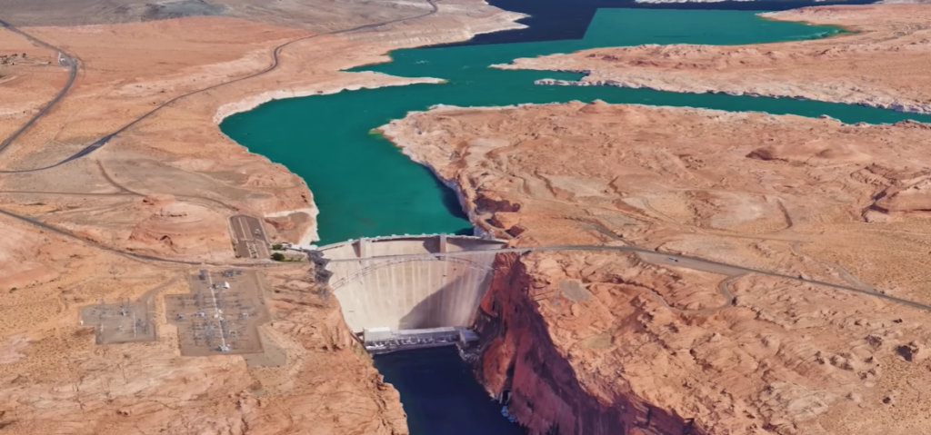
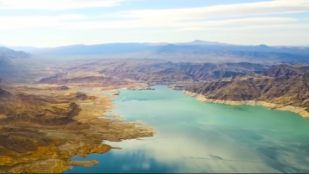
Lake Mead is the largest reservoir in the United States by volume when full, located on the Colorado River. It was formed by the construction of the Hoover Dam, which was completed in 1936. The lake provides water to millions of people in the southwestern United States, including residents of Nevada, Arizona, and California. It is a crucial component of the Colorado River Basin system, supplying water for agricultural irrigation, hydroelectric power generation, and municipal use.
Lake Mead proximity to Las Vegas and other cities, combined with its scenic location and recreational opportunities, has made it a key destination for tourism, outdoor activities, and water-based recreation in the southwestern United States.
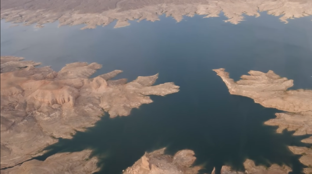
Table of Contents
Location of Lake Mead: Country, States, Cities
Lake Mead is located in the United States, primarily along the borders of Nevada (Clark County) and Arizona (Mohave County). The reservoir sits on the Colorado River, approximately 24–30 miles southeast of Las Vegas, and lies directly adjacent to Boulder City and Henderson in Nevada.
It is part of the Lake Mead National Recreation Area and was created by the construction of the Hoover Dam, extending from the Black Canyon upstream and bordering areas such as the Grand Canyon-Parashant National Monument.
| Category | Details |
|---|---|
| Country | United States |
| States | Nevada (Clark County), Arizona (Mohave County) |
| Nearby Cities | Las Vegas (NV), Boulder City (NV), Henderson (NV), Laughlin (NV/AZ) |
Size of Lake Mead: Surface Area, Volume, Length, Width, Depth Shoreline
| Metric | Full Capacity / Maximum | Notes |
|---|---|---|
| Surface Area | 247 sq mi (640 km²) | Drops as water level falls |
| Volume | 28.23 million acre-feet (34.82 km³) | Tier 1 Shortage Condition projected in 2026 |
| Length | 112–120 miles (180–190 km) | Varies with water level |
| Width | 10 miles (16 km) | Depends on water level |
| Depth | 532 ft (162 m) | Maximum near Hoover Dam |
| Shoreline | 550–759 miles (885–1,221 km) | Irregular, changes with lake level |
Surface Area of Lake Mead
Lake Mead covers a maximum surface area of 247 square miles (640 km²). This makes it one of the largest reservoirs in the United States. Its surface area varies depending on water levels, but at full capacity, it stretches across a vast expanse of the Nevada and Arizona landscape.
Volume of Lake Mead
At full capacity, Lake Mead holds approximately 28.23 million acre-feet (34.82 km³) of water. This makes it the largest reservoir in the United States by volume, serving as a critical water source for several states and supporting hydroelectric power generation.
Length of Lake Mead
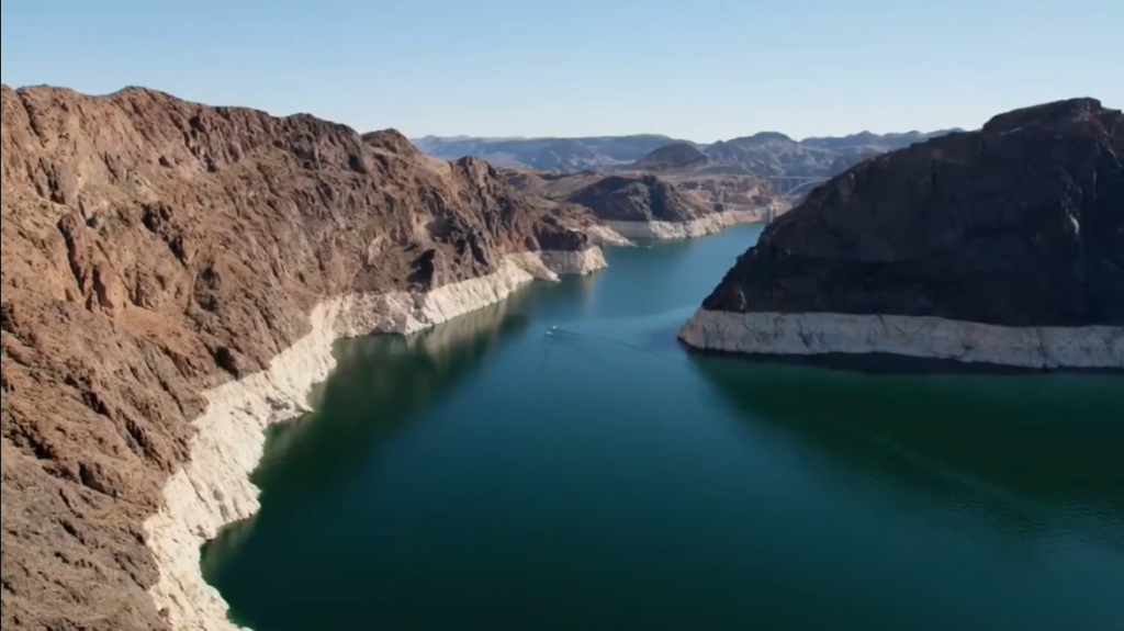
Lake Mead stretches 112 to 120 miles (180–190 km) along the Colorado River when full. Its long, narrow shape follows the river’s course through the Black Canyon and surrounding areas, giving it a striking and elongated appearance.
Width of Lake Mead
The lake reaches a maximum width of about 10 miles (16 km) at its widest points. Its width varies along the reservoir, depending on the shape of the river valley and surrounding terrain.
Depth of Lake Mead
Lake Mead has a maximum depth of 532 feet (162 m) near the Hoover Dam. Depth varies throughout the lake, with the deepest points close to the dam and shallower areas near the coves and shoreline.
Shoreline Length of Lake Mead
Lake Mead has a highly irregular shoreline, stretching approximately 550 to 759 miles (885–1,221 km). The shoreline includes numerous inlets, bays, and coves, creating many opportunities for recreation such as boating, fishing, and hiking.
Formation and History of Lake Mead
Formation of Lake Mead
Lake Mead was created by the construction of the Hoover Dam on the Colorado River, one of the largest rivers in the southwestern United States. The dam was built to control flooding, provide water storage, and generate hydroelectric power for Nevada, Arizona, and California. Work on the dam began in 1931 and was completed in 1935, during the Great Depression. The construction of Hoover Dam led to the flooding of the Black Canyon, forming what is now Lake Mead, the largest reservoir in the United States by volume.
The formation of Lake Mead transformed the surrounding desert landscape. The reservoir stretches across parts of Nevada and Arizona, creating a vast body of water in an otherwise arid region. Its creation not only provided a reliable water supply for cities and farms downstream but also made the area suitable for recreation and tourism.
Early History
Before the construction of Hoover Dam, the Colorado River flowed freely through the Black Canyon. The region was largely remote and sparsely populated, with small towns, mining operations, and Native American communities along the river. The river’s flow was unpredictable, causing frequent flooding in the lower basin.
The idea of building a dam in the Black Canyon was first proposed in the 1920s as part of a larger plan to manage water resources in the southwestern United States. After approval from Congress, the U.S. Bureau of Reclamation began the massive project, employing thousands of workers. The dam required innovative engineering techniques for its time and became a symbol of American ingenuity.
Construction of Hoover Dam
The construction of Hoover Dam was one of the greatest engineering achievements of the 20th century. Workers faced extreme heat, dangerous conditions, and the challenges of diverting the Colorado River through massive tunnels to allow the dam to be built. The project required concrete pouring on an unprecedented scale, and innovative cooling techniques were used to prevent the massive structure from cracking as it set.
When the dam was completed in 1935, it immediately began impounding water behind it, gradually filling the reservoir. The name Lake Mead was chosen in honor of Elwood Mead, the commissioner of the U.S. Bureau of Reclamation who oversaw the project.
Later History and Development
After its formation, Lake Mead became a vital resource for the southwestern United States. It supplies water for agriculture, industry, and cities, including Las Vegas and Los Angeles, and supports hydroelectric power generation at Hoover Dam. The lake also became a popular destination for recreation, attracting millions of visitors annually for boating, fishing, hiking, and sightseeing.
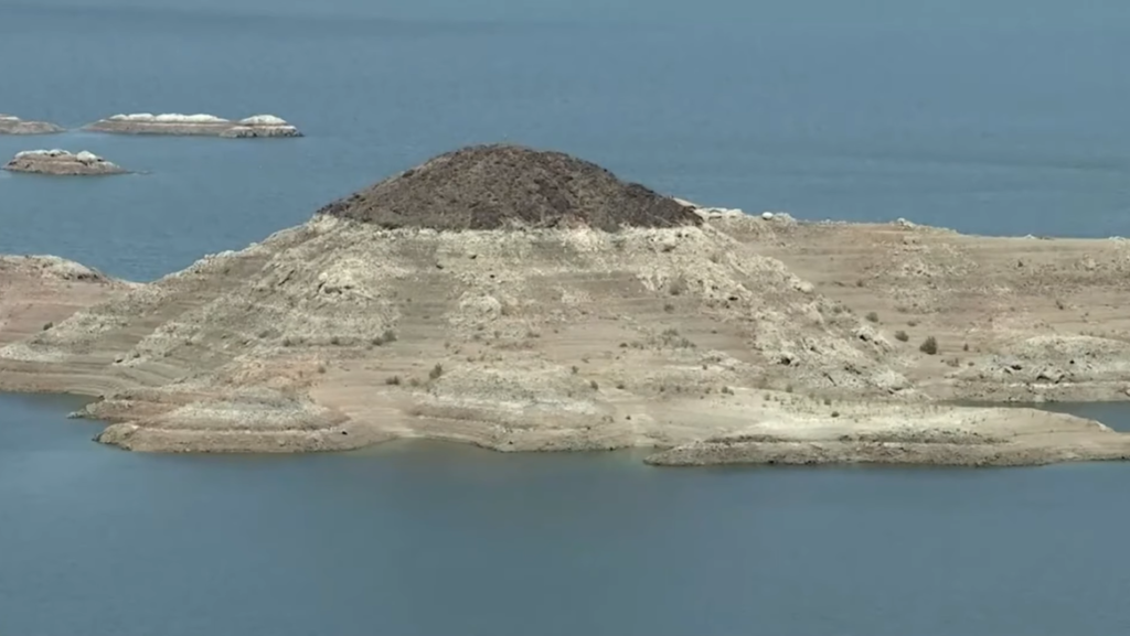
Over the decades, Lake Mead has faced challenges such as drought and water demand growth, which have caused fluctuations in water levels. Despite these challenges, the lake remains a crucial part of the region’s water management system and an iconic landmark of the American Southwest.
Why is Lake Mead drying up?
Lake Mead, the largest reservoir in the United States, has experienced a steady decline in water levels over the past decades. The primary reason for this is a prolonged drought in the southwestern United States. This region has seen below-average rainfall and reduced snowpack in the Rocky Mountains, which feed the Colorado River—the main source of water for Lake Mead. With less water flowing into the reservoir, the lake struggles to maintain its historical levels.
Another major factor is increased water demand. Lake Mead provides water for millions of people in Nevada, Arizona, and California, including major cities such as Las Vegas, Phoenix, and Los Angeles. The growing population in these areas has led to higher water consumption for households, agriculture, and industry. Over time, this demand has exceeded the natural replenishment of the lake, contributing to declining levels.
Climate change has also played a significant role. Rising temperatures increase evaporation from the lake and reduce snowpack in the mountains that supply the Colorado River. Hotter conditions also lead to drier soils and less runoff, further reducing the water that reaches Lake Mead. Scientists warn that continued climate change could make droughts more frequent and severe in the region, putting additional pressure on the reservoir.
Additionally, water management and allocation issues have impacted Lake Mead. The Colorado River Compact and other agreements divide water among seven U.S. states and Mexico. During periods of drought, these allocations can strain the reservoir, as upstream usage reduces the amount of water reaching Lake Mead. Inefficient water practices, such as over-irrigation in agriculture, have further compounded the problem.
In summary, Lake Mead is drying up due to a combination of prolonged drought, increased water demand, climate change, and water management challenges. The shrinking water levels highlight the vulnerability of this critical resource and underscore the need for sustainable water use and conservation efforts in the southwestern United States.
Temperature of Lake Mead
The water temperature of Lake Mead varies throughout the year and at different depths. Surface temperatures can range from around 50°F (10°C) in winter to 85°F (29°C) or higher in summer, especially in shallow areas near the shoreline. Deeper parts of the lake, particularly near the Hoover Dam, are generally cooler and remain around 50–60°F (10–16°C) even during warmer months.
The warm surface temperatures in summer make Lake Mead ideal for boating, swimming, and water sports, while the cooler deeper areas provide a habitat for fish such as largemouth bass, striped bass, and catfish. Seasonal temperature changes also affect recreational activities, with peak tourism occurring in late spring through early fall when water temperatures are most comfortable.
Seasonal Temperature Pattern of Lake Mead
| Season / Month | Surface Water Temperature (°F) | Surface Water Temperature (°C) | Notes |
|---|---|---|---|
| Winter (Dec–Feb) | 50–55°F | 10–13°C | Coldest period; swimming is less comfortable |
| Spring (Mar–May) | 60–70°F | 16–21°C | Water begins warming; ideal for boating and fishing |
| Summer (Jun–Aug) | 80–85°F | 27–29°C | Warmest period; popular for swimming and water sports |
| Fall (Sep–Nov) | 70–75°F | 21–24°C | Water gradually cools; still comfortable for recreation |
Month-Wise Surface Temperature of Lake Mead
| Month | Surface Water Temperature (°F) | Surface Water Temperature (°C) |
|---|---|---|
| January | 50–52°F | 10–11°C |
| February | 51–54°F | 11–12°C |
| March | 55–59°F | 13–15°C |
| April | 60–64°F | 16–18°C |
| May | 65–70°F | 18–21°C |
| June | 75–80°F | 24–27°C |
| July | 80–85°F | 27–29°C |
| August | 82–85°F | 28–29°C |
| September | 78–82°F | 26–28°C |
| October | 70–75°F | 21–24°C |
| November | 60–65°F | 16–18°C |
| December | 52–55°F | 11–13°C |
Major Rivers Feeding Lake Mead
Lake Mead is primarily fed by the Colorado River, which provides nearly 97% of the reservoir’s total water inflow. The Colorado River originates in the Rocky Mountains and flows through the Colorado Plateau before reaching Lake Mead, making it the lake’s most important and consistent water source.
In addition to the Colorado River, several smaller tributaries contribute to Lake Mead. The Virgin River flows from the north into the Overton Arm of the lake, while the Muddy River joins the Virgin River system before entering the reservoir. Another contributor is the Las Vegas Wash, a smaller stream that drains the Las Vegas Valley and enters Lake Mead at Las Vegas Bay.
| Tributary | Location / Entry Point | Contribution |
|---|---|---|
| Colorado River | Flows from the Rocky Mountains through the Colorado Plateau | Primary source (~96.9% of total inflow) |
| Virgin River | Northern part of the lake, entering the Overton Arm | Major tributary, joins northern part of the lake |
| Muddy River | Flows from the north, joins Virgin River system | Contributes smaller inflow via Virgin River |
| Las Vegas Wash | Enters at Las Vegas Bay | Smaller tributary, drains Las Vegas Valley |
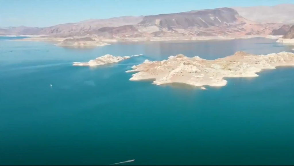
Islands in Lake Mead
Lake Mead National Recreation Area is home to several islands, primarily located in the Boulder Basin and Overton Arm. These islands feature rocky terrain, volcanic formations, and scenic desert landscapes. Many of them are popular for recreational activities such as boating, swimming, kayaking, and fishing, offering visitors unique spots to explore within the reservoir.
Some of the notable islands include the Boulder Islands, located in the Boulder Basin near Las Vegas. These islands are famous for their dramatic rock formations and are popular for kayaking and sightseeing. Saddle Island, also in the Boulder Basin, is easily accessible from the southern part of the lake and is frequently mentioned in water and navigation reports. In the Overton Arm, the Overton Islands form a small chain that provides a quieter, more remote experience compared to the main basin. The Black Ridge Islands, a collection of volcanic islands in the Boulder Basin, are primarily reachable by boat and are known for their rugged beauty.
Most islands can be accessed by motorboat, kayak, or canoe, with some located near marinas and popular recreation areas like Boulder Beach. Visitors enjoy fishing, swimming, exploring small caves, and taking in the surrounding desert scenery.
| Island | Location | Access | Recreational Notes |
|---|---|---|---|
| Boulder Islands | Boulder Basin, near Las Vegas | Motorboat, kayak | Known for stunning rock formations; popular for kayaking and sightseeing |
| Saddle Island | Boulder Basin, southern part of the lake | Motorboat, kayak | Easily accessible; frequently mentioned in water reports; good for boating and exploration |
| Overton Islands | Overton Arm | Motorboat, kayak | Small chain of islands; quieter, scenic, remote experience |
| Black Ridge Islands | Boulder Basin | Boat | Volcanic islands; rugged terrain; popular for exploring and photography |
Wildlife in Lake Mead
Lake Mead National Recreation Area supports a diverse ecosystem, making it a haven for nature enthusiasts and wildlife watchers.
Animals in Lake Mead
| Category | Species / Examples | Notes / Habitat |
|---|---|---|
| Mammals | Desert bighorn sheep, coyotes, bobcats, mule deer, badgers, ringtail cats, jackrabbits | Bighorn sheep often seen on rocky cliffs; bats (19+ species) inhabit caves and shaded areas |
| Birds | Bald eagles, peregrine falcons, great horned owls, American coot, mallards, shorebirds, greater roadrunner | Bald eagles common in winter; waterbirds found near lake edges; raptors soar over canyons |
| Fish | Striped bass, largemouth/smallmouth bass, channel catfish, black crappie, bluegill, razorback sucker (endangered), flannelmouth sucker | Game fish popular for fishing; native razorback sucker has a self-sustaining population |
| Reptiles | Gila monsters, desert tortoises, rattlesnakes | Found throughout desert areas; visitors should be cautious |
Fish Found in Lake Mead
| Fish Species | Notes |
|---|---|
| Striped bass | Popular for recreational fishing; stocked in some areas |
| Largemouth bass | Common game fish; often found near coves and shoreline |
| Smallmouth bass | Found in deeper, cooler parts of the lake |
| Channel catfish | Popular with anglers; thrives throughout the lake |
| Black crappie | Found in coves and around submerged structures |
| Bluegill | Common panfish; often caught near shore |
| Razorback sucker (endangered) | Native species; protected, self-sustaining population |
| Flannelmouth sucker | Native species; contributes to lake’s natural ecosystem |
| Sunfish | Found in shallow waters; supports local food chain |
| Carp | Introduced species; widespread in various parts of the lake |
Biggest Fish in Lake Mead
| Fish Species | Maximum Size / Weight | Notes |
|---|---|---|
| Striped bass | Up to 45 inches / 50 lbs | Popular game fish; large specimens often caught near deep channels |
| Largemouth bass | Up to 30 inches / 20 lbs | Found near coves and submerged structures; prized by anglers |
| Smallmouth bass | Up to 27 inches / 12 lbs | Prefers rocky areas and cooler, deeper waters |
| Channel catfish | Up to 40 inches / 40 lbs | Thrives throughout the lake; excellent for sport fishing |
| Carp | Up to 40 inches / 35 lbs | Introduced species; can grow large and are widespread |
Aquatic Plants in Lake Mead
Aquatic plants in Lake Mead are often dominated by invasive species, with Hydrilla (Hydrilla verticillata) and Crisp-leaved Pondweed (Potamogeton crispus) being the most significant. These plants thrive in shallow, sunlit areas of the reservoir, providing habitat for fish but also impacting water quality. While these species support recreational fish such as striped bass and largemouth bass, they are not native and can grow aggressively, forming dense beds that interfere with boating, irrigation, and water intake systems.
Other aquatic vegetation in Lake Mead may include various pondweeds, algae, and emergent plants along the shoreline. However, the arid environment and fluctuating water levels limit the density and diversity of native aquatic plants. Surrounding the reservoir, the desert landscape features native flora like brittlebush and desert sage, which thrive along the shoreline and contribute to the lake’s desert ecosystem.
| Plant Species | Type | Impact / Notes |
|---|---|---|
| Hydrilla (Hydrilla verticillata) | Invasive | Grows aggressively in shallow water; provides fish habitat but can clog waterways and affect water quality |
| Crisp-leaved Pondweed (Potamogeton crispus) | Invasive | Forms dense beds; offers cover for fish but reduces water flow and recreational access |
| Various Pondweeds | Likely Native / Introduced | Provide habitat for fish; growth limited by water levels and arid conditions |
| Algae | Various Species | Supports aquatic food web; excessive growth can reduce water quality |
| Emergent Shoreline Plants | Native | Includes desert scrub species along edges; limited due to fluctuating water levels |
Recreational Activities
Lake Mead National Recreation Area, managed by the National Park Service, spans over 1.5 million acres and offers a wide variety of year-round recreational opportunities for visitors. The area is ideal for both water-based and land-based activities, providing options for families, adventurers, and nature enthusiasts alike.
Water Activities
Boating is one of the most popular pastimes at Lake Mead, with marinas such as Hemenway Harbor, Callville Bay, and Temple Bar offering rentals for houseboats, pontoons, and jet skis. Swimming is popular at Boulder Beach, Sandy Beach, and various coves along Lake Mohave, while kayaking and paddleboarding are favorite activities on the Black Canyon Water Trail, including trips to the Arizona Hot Springs. Anglers can enjoy year-round fishing for species like striped bass, catfish, and sunfish, and scuba divers can explore underwater landscapes, including a submerged B-29 bomber.
Land-Based Activities
Lake Mead also offers a wide range of land-based recreation. There are over 200 miles of hiking trails, ranging from easy walks like the Historic Railroad Trail to challenging routes such as the Gold Strike Hot Spring trail. Biking enthusiasts can ride the 34-mile paved River Mountains Loop Trail, while campers have access to over 900 sites, including six National Park Service-managed campgrounds at locations like Boulder Beach and Las Vegas Bay. Scenic drives, such as along Northshore Road, provide breathtaking views of the lake and desert, while wildlife viewing offers opportunities to spot desert bighorn sheep, coyotes, and various bird species.
Sightseeing and Tours
A highlight of any visit is the Hoover Dam, where guided tours provide insight into this engineering marvel. Educational programs, visitor center exhibits, and ranger-led tours allow visitors to learn about the lake’s history, ecology, and the significance of water management in the region.
| Category | Activities / Locations | Notes / Highlights |
|---|---|---|
| Water Activities | Boating – Hemenway Harbor, Callville Bay, Temple Bar | Rentals for houseboats, pontoons, jet skis |
| Water Activities | Swimming – Boulder Beach, Sandy Beach, Lake Mohave coves | Popular for families and casual swimmers |
| Water Activities | Kayaking / Paddleboarding – Black Canyon Water Trail, Arizona Hot Springs | Scenic trips through canyons; ideal for adventure seekers |
| Water Activities | Fishing – Striped bass, catfish, sunfish | Year-round fishing; both shore and boat options |
| Water Activities | Scuba Diving | Explore underwater landscapes, including submerged B-29 bomber |
| Land Activities | Hiking & Trails – Historic Railroad Trail, Gold Strike Hot Spring | Over 200 miles of trails from easy to challenging |
| Land Activities | Biking – River Mountains Loop Trail | 34-mile paved loop for biking enthusiasts |
| Land Activities | Camping & Lodging – Boulder Beach, Las Vegas Bay | Over 900 campsites including six NPS-managed campgrounds |
| Land Activities | Scenic Driving – Northshore Road | Views of lake and desert; accessible by car |
| Land Activities | Wildlife Viewing | Desert bighorn sheep, coyotes, birds; best early morning/evening |
| Sightseeing & Tours | Hoover Dam | Guided tours of engineering marvel |
| Sightseeing & Tours | Educational Programs | Visitor center exhibits, ranger-led tours, historical sites |
Importance of Lake Mead
Lake Mead is one of the most significant reservoirs in the United States, providing critical water resources for millions of people across the southwestern region. The lake stores water from the Colorado River and supplies it to Nevada, Arizona, and California, supporting urban areas, agriculture, and industrial activities. Cities such as Las Vegas, Phoenix, and Los Angeles rely on Lake Mead for their municipal water supply, making it essential for sustaining the region’s growing population.
In addition to water storage, Lake Mead plays a vital role in hydroelectric power generation. The Hoover Dam, which created the lake, produces renewable energy for Nevada, Arizona, and California, powering homes, businesses, and infrastructure. This energy production reduces dependence on fossil fuels and contributes to regional energy security.
Lake Mead also provides flood control for the lower Colorado River, helping to manage seasonal flows and reduce the risk of flooding downstream. By regulating water release, it protects communities, farmland, and ecosystems that depend on the river’s natural flow.
Beyond its practical uses, Lake Mead is an important recreational and ecological resource. The lake and surrounding national recreation area offer boating, fishing, hiking, camping, wildlife viewing, and scenic experiences, drawing millions of visitors each year. The lake also supports a diverse ecosystem, including fish, birds, mammals, and aquatic plants, providing habitat in an otherwise arid desert region.
Famous Ships Sunk in Lake Mead
Shrinking water levels in Lake Mead have revealed several historically significant submerged vessels, offering a fascinating glimpse into the lake’s past. Among the most notable discoveries is a World War II-era Higgins boat (LCVP), a landing craft used by Allied forces during the war, including the D-Day invasions. This surplus vessel likely served in surveying or recreational use on the Colorado River before sinking, and it emerged as water levels dropped during recent droughts.
Another significant wreck is a 1948 Boeing B-29 Superfortress bomber, which crashed into the Overton Arm while carrying secret high-altitude atmospheric research equipment. The wreck was rediscovered in 2001 and is now listed on the National Register of Historic Places, highlighting its historical and technological importance.
In addition to these, other vessels have appeared as the shoreline recedes. The “Skyward” cabin cruiser, identified by its chrome railing, was found in what is referred to as the boat graveyard. Numerous smaller recreational boats, including some dating back to the 1930s, have also surfaced, revealing a significant inventory of sunken vessels beneath the lake.
These discoveries not only provide insight into the military, recreational, and industrial history of Lake Mead but also serve as a unique attraction for historians, divers, and curious visitors. They highlight how changes in water levels can uncover hidden aspects of the region’s past, preserving artifacts that might otherwise remain lost beneath the water.
| Vessel Name | Type / Description | Year / Era | Notes / Historical Significance |
|---|---|---|---|
| Higgins Boat (LCVP) | WWII landing craft | 1940s | Used by Allied forces during World War II, including D-Day; possibly used for Colorado River surveying before sinking |
| Boeing B-29 Superfortress | Bomber aircraft | 1948 | Crashed in Overton Arm while carrying secret high-altitude research equipment; listed on National Register of Historic Places |
| Skyward | Cabin cruiser | Unknown | Identified by chrome railing; located in the “boat graveyard” area |
| Various Recreational Boats | Speedboats and small boats | 1930s–1990s | Sunken due to accidents, abandonment, or storms; highlight historical recreational use of the lake |
| Other Unnamed Vessels | Small private boats | Various | Many remain submerged and occasionally resurface as water levels drop |
Scary Facts About Lake Mead
| Fact | Details / Explanation |
|---|---|
| Shrinking Water Levels | Lake Mead has dropped over 160 feet from full capacity, revealing submerged objects and reducing water supply. |
| Sunken Vessels | WWII Higgins boat, 1948 B-29 bomber, and numerous recreational boats have surfaced due to drought, showing decades-old wrecks. |
| Drought Impact | Prolonged drought in the Southwest has severely limited inflow from the Colorado River, threatening water security. |
| Invasive Aquatic Plants | Hydrilla and Crisp-leaved Pondweed grow aggressively, clog waterways, reduce water quality, and affect fish habitats. |
| Dangerous Wildlife | Includes rattlesnakes, Gila monsters, and other venomous species; visitors must maintain caution. |
| Extreme Desert Conditions | High summer temperatures and dry conditions can cause dehydration, heatstroke, or accidents during hiking and boating. |
| Boating Hazards | Submerged rocks, fluctuating water levels, and old wrecks create risks for boats and swimmers. |
| Endangered Species at Risk | Native razorback sucker and other aquatic species are threatened by shrinking habitats and invasive species. |
Quick Facts About Lake Mead
| Category | Details |
|---|---|
| Location | United States; borders Nevada (Clark County) and Arizona (Mohave County) |
| Nearby Cities / Areas | Boulder City (NV), Henderson (NV), Las Vegas (NV); part of Lake Mead National Recreation Area |
| Formed By | Hoover Dam on the Colorado River |
| Surface Area | 247 sq miles (full capacity) |
| Volume | Maximum ~28.23 million acre-feet |
| Length | Up to 120 miles |
| Width | Maximum 10 miles |
| Maximum Depth | 532 feet near Hoover Dam |
| Shoreline Length | 550–759 miles, depending on water level |
| Primary Water Source | Colorado River (~96.9% of inflow) |
| Other Tributaries | Virgin River, Muddy River, Las Vegas Wash |
| Islands | Boulder Islands, Saddle Island, Overton Islands, Black Ridge Islands |
| Fish | Striped bass, largemouth bass, smallmouth bass, channel catfish, black crappie, bluegill, razorback sucker (endangered), flannelmouth sucker, sunfish, carp |
| Aquatic Plants | Hydrilla (invasive), Crisp-leaved Pondweed (invasive), various pondweeds, algae, emergent shoreline plants |
| Mammals | Desert bighorn sheep, coyotes, bobcats, mule deer, badgers, ringtail cats, jackrabbits, 19+ species of bats |
| Birds | Bald eagles, peregrine falcons, great horned owls, American coots, mallards, shorebirds, greater roadrunner |
| Reptiles | Gila monsters, desert tortoises, rattlesnakes |
| Recreational Activities | Boating, fishing, swimming, kayaking, paddleboarding, scuba diving, hiking, biking, camping, scenic driving, wildlife viewing, Hoover Dam tours |
| Historic Wrecks | WWII Higgins boat (LCVP), 1948 B-29 Superfortress bomber, “Skyward” cabin cruiser, other recreational boats |
| Importance | Water supply for Nevada, Arizona, California; hydroelectric power via Hoover Dam; flood control; recreation; habitat for diverse wildlife |
| Visitor Tips | Open year-round; entrance fee required; best hiking in spring/fall, best water activities in summer; check weather and water conditions |
Frequently Asked Questions About Lake Mead
Q. Where is Lake Mead located? / What state is Lake Mead in?
A. Lake Mead is on the Colorado River, spanning between the U.S. states of Nevada and Arizona, just southeast of Las Vegas.
Q. How big is Lake Mead?
A. At full capacity, Lake Mead covers about 247 square miles (640 km²) and can hold around 26.12 million acre-feet of water.
Q. How deep is Lake Mead?
A. At its maximum depth, Lake Mead can reach depths of over 500 feet (150 meters).
Q. What feeds Lake Mead?
A. Lake Mead is primarily fed by the Colorado River.
Q. What rivers feed Lake Mead?/What rivers feeds Lake Mead?
A. Lake Mead is mainly fed by the Colorado River. Other smaller rivers include the Virgin River, Muddy River, and Las Vegas Wash.